IMAGES TAKEN NEAR TO
Birchett Lane, ASHFORD, TN26 2ED
Introduction
This page details the photographs taken nearby to Birchett Lane, TN26 2ED by members of the Geograph project.
The Geograph project started in 2005 with the aim of publishing, organising and preserving representative images for every square kilometre of Great Britain, Ireland and the Isle of Man.

There are currently over 7.5m images from over14,400 individuals and you can help contribute to the project by visiting https://www.geograph.org.uk
Image Map
Images are licensed for reuse under creativecommons.org/licenses/by-sa/2.0
Notes
- Clicking on the map will re-center to the selected point.
- The higher the marker number, the further away the image location is from the centre of the postcode.
Image Listing (19 Images Found)
Images are licensed for reuse under creativecommons.org/licenses/by-sa/2.0
Image
Details
Distance
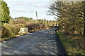
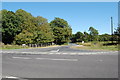
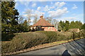
1
Staggered cross roads on Hamstreet Road
Hamstreet Road from Hamstreet and the A2070, leads straight on towards Bromley Green. Capel Road leads right towards Capel House and Haberdashers Wood.
Birchett Lane leads left towards Faggs Wood (part of Orlestone Forest) and onwards to Spot House Farm.
Image: © David Anstiss
Taken: 29 Aug 2010
0.03 miles
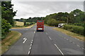
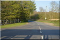
4
Junction of Capel Road and Hamstreet Road
Image: © Julian P Guffogg
Taken: 9 Sep 2012
0.06 miles
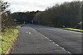
6
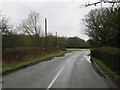
Cross Roads at St Thomas Cross
Looking south-westward.
Image: © Peter Wood
Taken: 13 Feb 2016
0.07 miles
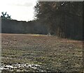
9
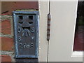
Ordnance Survey Flush Bracket 2848
This can be found on the wall of a private dwelling at St Thomas Cross.
For more detail see : http://www.bench-marks.org.uk/bm11996
Image: © Peter Wood
Taken: 13 Feb 2016
0.10 miles