IMAGES TAKEN NEAR TO
The Street, ASHFORD, TN26 2BX
Introduction
This page details the photographs taken nearby to The Street, TN26 2BX by members of the Geograph project.
The Geograph project started in 2005 with the aim of publishing, organising and preserving representative images for every square kilometre of Great Britain, Ireland and the Isle of Man.

There are currently over 7.5m images from over14,400 individuals and you can help contribute to the project by visiting https://www.geograph.org.uk
Image Map (Loading...)


Getting Data...Please wait
Leaflet Map data © OpenStreetMap
Images are licensed for reuse under creativecommons.org/licenses/by-sa/2.0
Notes
- Clicking on the map will re-center to the selected point.
- The higher the marker number, the further away the image location is from the centre of the postcode.
Image Listing (284 Images Found)
Images are licensed for reuse under creativecommons.org/licenses/by-sa/2.0
Image
Details
Distance
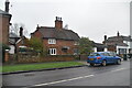
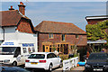
3
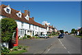
Appledore, The Street: Two fine detached houses
Image: © Michael Garlick
Taken: 15 Aug 2021
0.01 miles
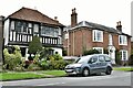
4

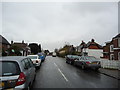
B2080 becomes The Street
The Street is the imposing and attractive main thoroughfare of Appledore.
Image: © Stuart Logan
Taken: 25 Aug 2011
0.01 miles
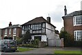
10
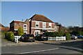
Converted stables off The Street
Grade II listed http://list.english-heritage.org.uk/resultsingle.aspx?uid=1300032
Image: © Oast House Archive
Taken: 21 Jul 2013
0.02 miles