IMAGES TAKEN NEAR TO
Steeds Lane, ASHFORD, TN26 1NH
Introduction
This page details the photographs taken nearby to Steeds Lane, TN26 1NH by members of the Geograph project.
The Geograph project started in 2005 with the aim of publishing, organising and preserving representative images for every square kilometre of Great Britain, Ireland and the Isle of Man.

There are currently over 7.5m images from over14,400 individuals and you can help contribute to the project by visiting https://www.geograph.org.uk
Image Map
Images are licensed for reuse under creativecommons.org/licenses/by-sa/2.0
Notes
- Clicking on the map will re-center to the selected point.
- The higher the marker number, the further away the image location is from the centre of the postcode.
Image Listing (6 Images Found)
Images are licensed for reuse under creativecommons.org/licenses/by-sa/2.0
Image
Details
Distance
1
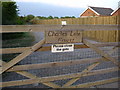
Gate
Entrance gate to Charlies Lake Fishery
Image: © D-G-Seamon
Taken: 5 May 2007
0.06 miles
2
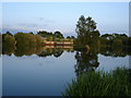
Charlies Lake Fishery
Evening looking east across Charlies Lake Fishery
Image: © D-G-Seamon
Taken: 5 May 2007
0.11 miles
3
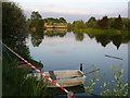
Anglers boat
Anglers boat on Charlies Lake
Image: © D-G-Seamon
Taken: 5 May 2007
0.12 miles
5
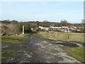
Track through Braeside Farm
The track is part of the Greensand Way.
Image: © John Baker
Taken: 31 Jan 2010
0.23 miles
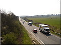
6
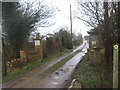
Byway into Braeside Farm
This byway from Steeds Lane is also part of the Greensand Way (long distance path) heading towards Lone Barn Farm.
Image: © David Anstiss
Taken: 21 Feb 2010
0.24 miles