IMAGES TAKEN NEAR TO
Steeds Lane, ASHFORD, TN26 1NE
Introduction
This page details the photographs taken nearby to Steeds Lane, TN26 1NE by members of the Geograph project.
The Geograph project started in 2005 with the aim of publishing, organising and preserving representative images for every square kilometre of Great Britain, Ireland and the Isle of Man.

There are currently over 7.5m images from over14,400 individuals and you can help contribute to the project by visiting https://www.geograph.org.uk
Image Map (Loading...)


Getting Data...Please wait
Leaflet Map data © OpenStreetMap
Images are licensed for reuse under creativecommons.org/licenses/by-sa/2.0
Notes
- Clicking on the map will re-center to the selected point.
- The higher the marker number, the further away the image location is from the centre of the postcode.
Image Listing (10 Images Found)
Images are licensed for reuse under creativecommons.org/licenses/by-sa/2.0
Image
Details
Distance
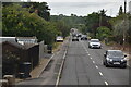
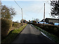
4
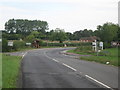
Crossroads near Kingsnorth
Ashford Road from Bromley Green heads straight on towards Kingsnorth, near Ashford. Magpie Hall Road heads left towards Stubb's Cross and the A28 Ashford Road. Steeds Lane leads right towards Braeside Farm and Sticketts Farm.
Image: © David Anstiss
Taken: 29 Aug 2010
0.16 miles
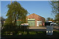
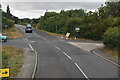
6
Disused Farm building beside Magpie Hall Road
As seen from Ashford Road.
Image: © David Anstiss
Taken: 29 Aug 2010
0.19 miles
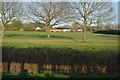
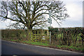
7
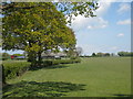
Fields near Bond Farm
From Steeds Lane.
Image: © Oast House Archive
Taken: 14 May 2010
0.20 miles
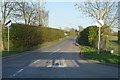
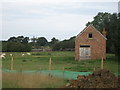
8
Bond Lane, Kingsnorth
The buildings on the right hand side of the lane are those of Bond Farm. The lane links Steeds Lane to Church Hill.
Image: © John Baker
Taken: 31 Jan 2010
0.20 miles
9
Pillbox, Tree and Gate
By the road to Stubbs Cross.
Image: © Robin Webster
Taken: 16 Feb 2007
0.21 miles