IMAGES TAKEN NEAR TO
Great Chart, ASHFORD, TN26 1JP
Introduction
This page details the photographs taken nearby to TN26 1JP by members of the Geograph project.
The Geograph project started in 2005 with the aim of publishing, organising and preserving representative images for every square kilometre of Great Britain, Ireland and the Isle of Man.

There are currently over 7.5m images from over14,400 individuals and you can help contribute to the project by visiting https://www.geograph.org.uk
Image Map (Loading...)


Getting Data...Please wait
Leaflet Map data © OpenStreetMap
Images are licensed for reuse under creativecommons.org/licenses/by-sa/2.0
Notes
- Clicking on the map will re-center to the selected point.
- The higher the marker number, the further away the image location is from the centre of the postcode.
Image Listing (12 Images Found)
Images are licensed for reuse under creativecommons.org/licenses/by-sa/2.0
Image
Details
Distance
4
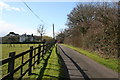
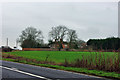
Driveway to Bevenden
Off the north side of the A28 between Ashford and Bethersden
Image: © Dr Neil Clifton
Taken: 18 Mar 2007
0.10 miles
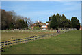
6
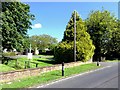
Lodge Place
The A28 bends round to pass in front of the grounds.
Image: © Robin Webster
Taken: 21 Mar 2010
0.13 miles
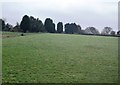
7
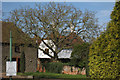
Bethersden, Spicer's Hill
Bethersden, Spicer's Hill, Ashford Road, A28, Lodge Place.
Image: © Helmut Zozmann
Taken: 22 Jul 2012
0.13 miles
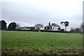
8
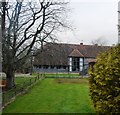
Oast House, Lodge Place, Ashford Road, Great Chart, Kent
Image: © Oast House Archive
Taken: 18 Mar 2009
0.13 miles
9
Bethersden, Spicer's Hill
Bethersden, Spicer's Hill, Ashford Road, A28, Lodge Place.
Image: © Helmut Zozmann
Taken: 22 Jul 2012
0.15 miles
10
Bethersden, Spicer's Hill
Bethersden, Spicer's Hill, Ashford Road, A28, Lodge Place.
Image: © Helmut Zozmann
Taken: 22 Jul 2012
0.16 miles