IMAGES TAKEN NEAR TO
Lone Field, ASHFORD, TN26 1HP
Introduction
This page details the photographs taken nearby to Lone Field, TN26 1HP by members of the Geograph project.
The Geograph project started in 2005 with the aim of publishing, organising and preserving representative images for every square kilometre of Great Britain, Ireland and the Isle of Man.

There are currently over 7.5m images from over14,400 individuals and you can help contribute to the project by visiting https://www.geograph.org.uk
Image Map
Images are licensed for reuse under creativecommons.org/licenses/by-sa/2.0
Notes
- Clicking on the map will re-center to the selected point.
- The higher the marker number, the further away the image location is from the centre of the postcode.
Image Listing (15 Images Found)
Images are licensed for reuse under creativecommons.org/licenses/by-sa/2.0
Image
Details
Distance
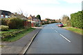
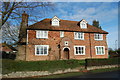
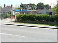
1
Corner Stone, Woodchurch Road
Planning permission was granted by Ashford Borough Council under application number 17/00200/AS for the “erection of a side extension”.
Image: © John Baker
Taken: 27 May 2018
0.06 miles
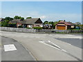
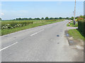
2
Road junction on Hornash Lane
Hornash Lane from Bromley Green, meets Woodchurch Road heading left towards Shadoxhurst, Woodchurch and Bethersden. Also Tally Ho Road heads right towards Ashford (via Stubb's Cross).
Image: © David Anstiss
Taken: 21 Feb 2010
0.08 miles
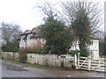
3

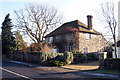
Shadoxhurst Village Hall
On Hornash Lane close to the junction with Woodchurch Road and Tally Ho Road.
Image: © David Anstiss
Taken: 21 Feb 2010
0.09 miles
4
View from Tally Ho Road
This tranquil, countryside vista will eventually become part of a vast development, to be known as Chilmington Green.
Planning permission has been granted by Ashford Borough Council under application number 12/00400/AS, for an “outline application for a Comprehensive Mixed Use Development comprising: up to 5,750 residential units, in a mix of sizes, types and tenures; up to 10,000 m² (gross external floor space) of Class Bl use; up to 9,000 m² (gross external floor space) of Class Al to A5 uses; Education (including a secondary school of up to 8 ha and up to four primary schools of up to 2.1 ha each); Community Uses (class Dl) up to 7,000 m² (gross external floor space); Leisure Uses (class D2) up to 6,000 m² (gross external floor space); Provision of local recycling facilities; Provision of areas of formal and informal open space; Installation of appropriate utilities infrastructure as required to serve the development, including flood attenuation works, SUDS, water supply and wastewater infrastructure, gas supply, electricity supply (including substations), telecommunications infrastructure and renewable energy infrastructure (including CHP in the District Centre); Transport infrastructure, including provision of three accesses on to the A28, an access on to Coulter Road/Cuckoo Lane, other connections on to the local road network, and a network of internal roads, footpaths and cycle routes; New planting and landscaping, both within the Proposed Development and on its boundaries, and ecological enhancement works; and associated ground works where appearance, landscaping, layout and scale are reserved for future approval and where access is reserved for future approval with the exception of the three accesses on to the A28 and the access on to Coulter Road/Cuckoo Lane”.
Image: © John Baker
Taken: 27 May 2018
0.10 miles
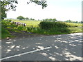
7
Tally Ho Road
The field, to the left of the road, will eventually become part of a vast development, to be known as Chilmington Green.
Planning permission has been granted by Ashford Borough Council under application number 12/00400/AS, for an “outline application for a Comprehensive Mixed Use Development comprising: up to 5,750 residential units, in a mix of sizes, types and tenures; up to 10,000 m² (gross external floor space) of Class Bl use; up to 9,000 m² (gross external floor space) of Class Al to A5 uses; Education (including a secondary school of up to 8 ha and up to four primary schools of up to 2.1 ha each); Community Uses (class Dl) up to 7,000 m² (gross external floor space); Leisure Uses (class D2) up to 6,000 m² (gross external floor space); Provision of local recycling facilities; Provision of areas of formal and informal open space; Installation of appropriate utilities infrastructure as required to serve the development, including flood attenuation works, SUDS, water supply and wastewater infrastructure, gas supply, electricity supply (including substations), telecommunications infrastructure and renewable energy infrastructure (including CHP in the District Centre); Transport infrastructure, including provision of three accesses on to the A28, an access on to Coulter Road/Cuckoo Lane, other connections on to the local road network, and a network of internal roads, footpaths and cycle routes; New planting and landscaping, both within the Proposed Development and on its boundaries, and ecological enhancement works; and associated ground works where appearance, landscaping, layout and scale are reserved for future approval and where access is reserved for future approval with the exception of the three accesses on to the A28 and the access on to Coulter Road/Cuckoo Lane”.
Image: © John Baker
Taken: 27 May 2018
0.14 miles
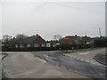
8
Sheenam, Woodchurch Road
Planning permission was granted by Ashford Borough Council under application number 17/00085/AS for a “roof extension, part two storey/part single storey rear/side extension incorporating integral garage, replacement porch and two front facing dormer windows”.
Image: © John Baker
Taken: 27 May 2018
0.14 miles