IMAGES TAKEN NEAR TO
Tally Ho Road, ASHFORD, TN26 1HL
Introduction
This page details the photographs taken nearby to Tally Ho Road, TN26 1HL by members of the Geograph project.
The Geograph project started in 2005 with the aim of publishing, organising and preserving representative images for every square kilometre of Great Britain, Ireland and the Isle of Man.

There are currently over 7.5m images from over14,400 individuals and you can help contribute to the project by visiting https://www.geograph.org.uk
Image Map (Loading...)


Getting Data...Please wait
Leaflet Map data © OpenStreetMap
Images are licensed for reuse under creativecommons.org/licenses/by-sa/2.0
Notes
- Clicking on the map will re-center to the selected point.
- The higher the marker number, the further away the image location is from the centre of the postcode.
Image Listing (7 Images Found)
Images are licensed for reuse under creativecommons.org/licenses/by-sa/2.0
Image
Details
Distance
3
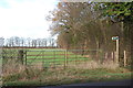
Entrance to Footpath off Tally Ho Road
Image: © Julian P Guffogg
Taken: 4 Dec 2012
0.14 miles
4
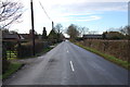
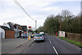
Junction on Tally Ho Road
Tally Ho Road leads from Stubb's Cross towards Shadoxhurst. Blindgrooms Lane heads left towards Blind Grooms Farm.
Image: © David Anstiss
Taken: 21 Feb 2010
0.17 miles
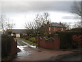
5
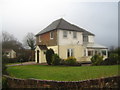
Blind Grooms Farmhouse
On Blindgrooms Lane. Beyond the farm the lane becomes a byway to Coxland Wood and Hornash Lane.
Image: © David Anstiss
Taken: 21 Feb 2010
0.18 miles
6
Stubbs Cross Post Office
The latest news on the Express stand was "Couple jailed for child abuse".
Image: © Robin Webster
Taken: 16 Feb 2007
0.23 miles
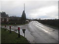
7
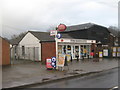
Stubb's Cross Post Office
As seen from the bus stop opposite on Tally Ho Road.
Compare with Image Notice the new building on the right.
Image: © David Anstiss
Taken: 21 Feb 2010
0.24 miles