IMAGES TAKEN NEAR TO
Maidstone Road, ASHFORD, TN26 1AG
Introduction
This page details the photographs taken nearby to Maidstone Road, TN26 1AG by members of the Geograph project.
The Geograph project started in 2005 with the aim of publishing, organising and preserving representative images for every square kilometre of Great Britain, Ireland and the Isle of Man.

There are currently over 7.5m images from over14,400 individuals and you can help contribute to the project by visiting https://www.geograph.org.uk
Image Map
Images are licensed for reuse under creativecommons.org/licenses/by-sa/2.0
Notes
- Clicking on the map will re-center to the selected point.
- The higher the marker number, the further away the image location is from the centre of the postcode.
Image Listing (2 Images Found)
Images are licensed for reuse under creativecommons.org/licenses/by-sa/2.0
Image
Details
Distance
1

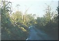
Watery Lane
Taken from the same location as Image time has completely healed the former devastation. The lane was living up to its name as the road surface was running with water due to a day of sunshine and showers
Image: © John Baker
Taken: 17 Jul 2011
0.06 miles
2
Watery Lane in 1987
This was taken one day after "The Great Storm" that swept in during the night of 15-16 October 1987 to devastate large swathes of Southern England.
Image: © John Baker
Taken: 17 Oct 1987
0.10 miles