IMAGES TAKEN NEAR TO
Frant Road, TUNBRIDGE WELLS, TN2 5SB
Introduction
This page details the photographs taken nearby to Frant Road, TN2 5SB by members of the Geograph project.
The Geograph project started in 2005 with the aim of publishing, organising and preserving representative images for every square kilometre of Great Britain, Ireland and the Isle of Man.

There are currently over 7.5m images from over14,400 individuals and you can help contribute to the project by visiting https://www.geograph.org.uk
Image Map
Images are licensed for reuse under creativecommons.org/licenses/by-sa/2.0
Notes
- Clicking on the map will re-center to the selected point.
- The higher the marker number, the further away the image location is from the centre of the postcode.
Image Listing (1811 Images Found)
Images are licensed for reuse under creativecommons.org/licenses/by-sa/2.0
Image
Details
Distance
3
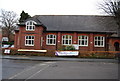
King Charles Church Hall
This is the church hall for the nearby King Charles The Martyr church.
Image: © N Chadwick
Taken: 28 Mar 2009
0.04 miles
4
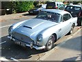
Vintage 1963 Aston Martin DB5, Warwick Park, Tunbridge Wells
Image: © Chris Whippet
Taken: 11 Oct 2015
0.04 miles
6
The Chalybeate Spring
It's free to 'taste the waters' !! .... can't give a verdict, as such a queue had grown between my taking this pic and advancing the few yards closer that we didn't have time to wait (from other comments here, I think I might have had a lucky escape).
Image: © Barbara Carr
Taken: 21 Sep 2010
0.04 miles