IMAGES TAKEN NEAR TO
Duncalf Road, TN2 5GU
Introduction
This page details the photographs taken nearby to Duncalf Road, TN2 5GU by members of the Geograph project.
The Geograph project started in 2005 with the aim of publishing, organising and preserving representative images for every square kilometre of Great Britain, Ireland and the Isle of Man.

There are currently over 7.5m images from over14,400 individuals and you can help contribute to the project by visiting https://www.geograph.org.uk
Image Map
Images are licensed for reuse under creativecommons.org/licenses/by-sa/2.0
Notes
- Clicking on the map will re-center to the selected point.
- The higher the marker number, the further away the image location is from the centre of the postcode.
Image Listing (85 Images Found)
Images are licensed for reuse under creativecommons.org/licenses/by-sa/2.0
Image
Details
Distance

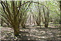
8
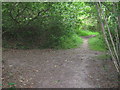
Footpath junction on Tunbridge Wells Circular
The long distance path turns right from Windmill Farm towards Tuttys Farm. Another path heads left towards Maryland Road, Hawkenbury. Another unofficial path heads forward into the woods.
Image: © David Anstiss
Taken: 20 Jul 2009
0.13 miles
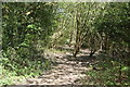
9
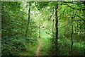
Tunbridge Wells Circular Path - through the woods near Tutty's Farm
Image: © N Chadwick
Taken: 27 Aug 2009
0.13 miles
