IMAGES TAKEN NEAR TO
Paddock Close, ASHFORD, TN25 7LL
Introduction
This page details the photographs taken nearby to Paddock Close, TN25 7LL by members of the Geograph project.
The Geograph project started in 2005 with the aim of publishing, organising and preserving representative images for every square kilometre of Great Britain, Ireland and the Isle of Man.

There are currently over 7.5m images from over14,400 individuals and you can help contribute to the project by visiting https://www.geograph.org.uk
Image Map
Images are licensed for reuse under creativecommons.org/licenses/by-sa/2.0
Notes
- Clicking on the map will re-center to the selected point.
- The higher the marker number, the further away the image location is from the centre of the postcode.
Image Listing (162 Images Found)
Images are licensed for reuse under creativecommons.org/licenses/by-sa/2.0
Image
Details
Distance
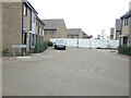
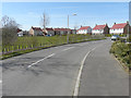
1
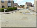
Paddock Close
Paddock Close is a road on a developing housing estate, which has been called Bridgefield 2, where 325 homes are to be built http://www.cradick.co.uk/properties/freehold/Bridgefield-Ashford-Ashford/421
The road is located at the far end of Image
Image: © John Baker
Taken: 11 Jul 2021
0.01 miles
2
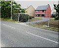
Cheeseman?s Green Lane
A path from this road leads into a developing housing estate, which has been called Bridgefield 2, where 325 homes are to be built http://www.cradick.co.uk/properties/freehold/Bridgefield-Ashford-Ashford/421
Image: © John Baker
Taken: 10 Oct 2021
0.01 miles
3
Cheeseman?s Green Lane
Behind the trees and bushes, on the right side of the road, is a developing housing estate, which has been called Bridgefield 2, where 325 homes are to be built http://www.cradick.co.uk/properties/freehold/Bridgefield-Ashford-Ashford/421
Image: © John Baker
Taken: 10 Oct 2021
0.02 miles
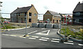
4
Farmstead Road
Part of a developing housing estate, which has been called Bridgefield 2, where 325 homes are to be built http://www.cradick.co.uk/properties/freehold/Bridgefield-Ashford-Ashford/421
A road sign, bearing this name, refers to a road and footpath.
Image: © John Baker
Taken: 23 Jan 2022
0.04 miles
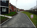
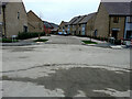
5
Meadow View
Meadow View is a road on a developing housing estate, which has been called Bridgefield 2, where 325 homes are to be built http://www.cradick.co.uk/properties/freehold/Bridgefield-Ashford-Ashford/421
Image: © John Baker
Taken: 10 Oct 2021
0.04 miles
6
Meadow View
Part of a developing housing estate, which has been called Bridgefield 2, where 325 homes are to be built http://www.cradick.co.uk/properties/freehold/Bridgefield-Ashford-Ashford/421
This was the distant view of Image before the road was opened to vehicles and pedestrians.
Image: © John Baker
Taken: 23 Jan 2022
0.04 miles
7
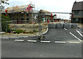
Farmstead Road
The road leads into a developing housing estate, which has been called Bridgefield 2, where 325 homes are to be built http://www.cradick.co.uk/properties/freehold/Bridgefield-Ashford-Ashford/421
Image: © John Baker
Taken: 6 Jun 2021
0.04 miles
8
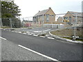
Farmstead Road
The road leads into a developing housing estate, which has been called Bridgefield 2, where 325 homes are to be built http://www.cradick.co.uk/properties/freehold/Bridgefield-Ashford-Ashford/421
This was the Image in July 2021.
Image: © John Baker
Taken: 10 Oct 2021
0.04 miles
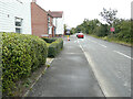
9
Looking west-northwest along Cheeseman?s Green Lane
Compared with Image, it may be seen how much the hedge has grown beside the road.
Image: © John Baker
Taken: 12 Apr 2015
0.04 miles
10
Farmstead Road
The road leads into a developing housing estate, which has been called ridgefield 2, where 325 homes are to be built http://www.cradick.co.uk/properties/freehold/Bridgefield-Ashford-Ashford/421
This is how the Image looked in June 2021.
Image: © John Baker
Taken: 11 Jul 2021
0.04 miles