IMAGES TAKEN NEAR TO
Dorset Crescent, ASHFORD, TN25 7FA
Introduction
This page details the photographs taken nearby to Dorset Crescent, TN25 7FA by members of the Geograph project.
The Geograph project started in 2005 with the aim of publishing, organising and preserving representative images for every square kilometre of Great Britain, Ireland and the Isle of Man.

There are currently over 7.5m images from over14,400 individuals and you can help contribute to the project by visiting https://www.geograph.org.uk
Image Map
Images are licensed for reuse under creativecommons.org/licenses/by-sa/2.0
Notes
- Clicking on the map will re-center to the selected point.
- The higher the marker number, the further away the image location is from the centre of the postcode.
Image Listing (94 Images Found)
Images are licensed for reuse under creativecommons.org/licenses/by-sa/2.0
Image
Details
Distance
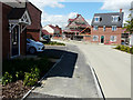
1
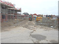
Looking northwest from Hadleigh Street
Along a road that will have houses built on either side of it. This is part of the Bridgefield housing estate.
Image: © John Baker
Taken: 25 Jan 2015
0.01 miles
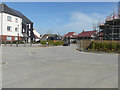
2
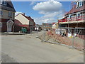
Looking north-northwest from Hadleigh Street
Compared with Image, much house building has taken place, on this part, of the Bridgefield housing estate.
Image: © John Baker
Taken: 19 Jul 2015
0.01 miles
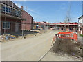
3
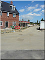
Hadleigh Street
The road is part of the Bridgefield housing estate.
Image: © John Baker
Taken: 19 Jul 2015
0.02 miles
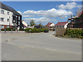
4
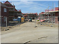
Looking northwest from Hadleigh Street
The houses lie on the Bridgefield housing estate.
Image: © John Baker
Taken: 12 Apr 2015
0.02 miles
5
Looking west along Hadleigh Street
I have assumed that this road will bear the name of Hadleigh Street, when the Ordnance Survey map is updated. It is part of the Bridgefield housing estate.
Image: © John Baker
Taken: 19 Jul 2015
0.03 miles
6
Looking north-northwest along Hadleigh Street
Compared with Image, the view of houses, in the distance, has been blotted out by houses in the process of being erected. This is part of the Bridgefield housing estate.
Image: © John Baker
Taken: 12 Apr 2015
0.03 miles
7
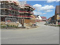
Looking northeast along Bodiam Avenue
The houses immediately on the left may be seen in Image This road, part of the Bridgefield housing estate, has yet to be added to the Ordnance Survey map.
Image: © John Baker
Taken: 19 Jul 2015
0.03 miles
8
Looking east along Bodiam Avenue
It is part of the Bridgefield housing estate, where houses are still being built.
Image: © John Baker
Taken: 12 Apr 2015
0.03 miles
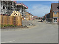
9
Looking east along Damara Way
From Finn Farm Road. The roads are thoroughfares on the Bridgefield housing estate.
Image: © John Baker
Taken: 12 Apr 2015
0.04 miles
10
Looking east-northeast along Damara Way
Compared with Image, work on the houses is gradually being completed. This is part of the Bridgefield housing estate.
Image: © John Baker
Taken: 19 Jul 2015
0.04 miles