IMAGES TAKEN NEAR TO
Aldington, ASHFORD, TN25 7BT
Introduction
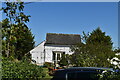
This page details the photographs taken nearby to TN25 7BT by members of the Geograph project.
The Geograph project started in 2005 with the aim of publishing, organising and preserving representative images for every square kilometre of Great Britain, Ireland and the Isle of Man.

There are currently over 7.5m images from over14,400 individuals and you can help contribute to the project by visiting https://www.geograph.org.uk
Image Map (Loading...)


Getting Data...Please wait
Leaflet Map data © OpenStreetMap
Images are licensed for reuse under creativecommons.org/licenses/by-sa/2.0
Notes
- Clicking on the map will re-center to the selected point.
- The higher the marker number, the further away the image location is from the centre of the postcode.
Image Listing (41 Images Found)
Images are licensed for reuse under creativecommons.org/licenses/by-sa/2.0
Image
Details
Distance


7
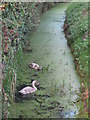
Cygnets near Lower Wall Road
These two young swans are in an algae filled drainage channel beside Lower Wall Road (bank on the right).
Image: © David Anstiss
Taken: 17 Oct 2010
0.07 miles