IMAGES TAKEN NEAR TO
Bonnington, ASHFORD, TN25 7BP
Introduction
This page details the photographs taken nearby to TN25 7BP by members of the Geograph project.
The Geograph project started in 2005 with the aim of publishing, organising and preserving representative images for every square kilometre of Great Britain, Ireland and the Isle of Man.

There are currently over 7.5m images from over14,400 individuals and you can help contribute to the project by visiting https://www.geograph.org.uk
Image Map
Images are licensed for reuse under creativecommons.org/licenses/by-sa/2.0
Notes
- Clicking on the map will re-center to the selected point.
- The higher the marker number, the further away the image location is from the centre of the postcode.
Image Listing (28 Images Found)
Images are licensed for reuse under creativecommons.org/licenses/by-sa/2.0
Image
Details
Distance
3
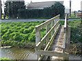
Sheep proof footbridge
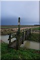
This is one of many footbridges that cross the profusion of dykes on the Romney Marsh
Image: © D-G-Seamon
Taken: 1 Apr 2007
0.01 miles
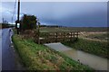
8
Lane bridge near Millfield Farm
This unnamed lane leads from Newchurch towards Eastbridge Road.
The bridge passes over one of many drains in the Romney Marshes.
In the background is Image
Image: © David Anstiss
Taken: 26 Sep 2010
0.04 miles