IMAGES TAKEN NEAR TO
Broadview Close, ASHFORD, TN25 7AQ
Introduction
This page details the photographs taken nearby to Broadview Close, TN25 7AQ by members of the Geograph project.
The Geograph project started in 2005 with the aim of publishing, organising and preserving representative images for every square kilometre of Great Britain, Ireland and the Isle of Man.

There are currently over 7.5m images from over14,400 individuals and you can help contribute to the project by visiting https://www.geograph.org.uk
Image Map
Images are licensed for reuse under creativecommons.org/licenses/by-sa/2.0
Notes
- Clicking on the map will re-center to the selected point.
- The higher the marker number, the further away the image location is from the centre of the postcode.
Image Listing (110 Images Found)
Images are licensed for reuse under creativecommons.org/licenses/by-sa/2.0
Image
Details
Distance
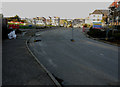
1
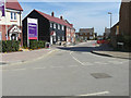
Looking north along Finn Farm Road
Compared with Image, the terrace of houses, in the distance, now have had their roof timbers erected. This is part of the Bridgefield housing estate.
Image: © John Baker
Taken: 19 Jul 2015
0.02 miles
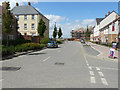
2
Looking north along Finn Farm Road
Towards houses that are being erected; they lie on the Bridgefield housing estate.
Image: © John Baker
Taken: 12 Apr 2015
0.03 miles
4
Fence across Finn Farm Road
Work is being carried to lay a new surface to the pavement on the left, while on the opposite side of the road, judging by the piles of bricks, it appears that the area is due to be paved. This road is part of the Bridgefield housing estate.
Image: © John Baker
Taken: 29 Oct 2017
0.03 miles
5
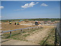
Countryside Housing Development
New housing estate being built in green fields East of the A2070.
Image: © Oast House Archive
Taken: 14 May 2010
0.05 miles
6
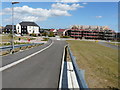
Looking east from a ramp, Bridgefield housing estate
The ramp carries a path, over the Ashford to Hastings railway line and the A2070, into the Park Farm housing estate. The houses, immediately ahead, are in Damara Way while those, either side of this road’s entrance, are in Finn Farm Road.
Image: © John Baker
Taken: 19 Jul 2015
0.05 miles
7
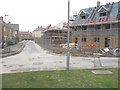
Looking northwest along Hadleigh Street
Some of the houses are still in the process of being built along this road. This is part of the Bridgefield housing estate.
Image: © John Baker
Taken: 25 Jan 2015
0.05 miles
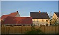
8
Looking northwest along Hadleigh Street
Compared with Image, the last finishing touches are being added to the houses; they lie on the Bridgefield housing estate.
Image: © John Baker
Taken: 12 Apr 2015
0.05 miles
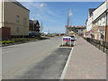
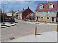
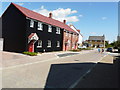
9
Hadleigh Street, Bridgefield housing estate
Viewed from Finn Farm Road, a couple of the houses are having the final touches added to their frontages.
Image: © John Baker
Taken: 12 Apr 2015
0.05 miles
10
Looking east along Hadleigh Street
The view of Image shows the road from the other direction, before the work on the houses, on the Bridgefield housing estate, was completed.
Image: © John Baker
Taken: 19 Jul 2015
0.06 miles