IMAGES TAKEN NEAR TO
Smeeth, ASHFORD, TN25 6SS
Introduction
This page details the photographs taken nearby to TN25 6SS by members of the Geograph project.
The Geograph project started in 2005 with the aim of publishing, organising and preserving representative images for every square kilometre of Great Britain, Ireland and the Isle of Man.

There are currently over 7.5m images from over14,400 individuals and you can help contribute to the project by visiting https://www.geograph.org.uk
Image Map (Loading...)


Getting Data...Please wait
Leaflet Map data © OpenStreetMap
Images are licensed for reuse under creativecommons.org/licenses/by-sa/2.0
Notes
- Clicking on the map will re-center to the selected point.
- The higher the marker number, the further away the image location is from the centre of the postcode.
Image Listing (4 Images Found)
Images are licensed for reuse under creativecommons.org/licenses/by-sa/2.0
Image
Details
Distance
1
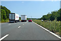
Coast-bound M20
Plenty of continental freight traffic, despite it being a Sunday.
Image: © Robin Webster
Taken: 8 Jul 2018
0.19 miles
2
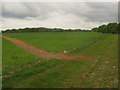
Footpath to Park Wood
A footpath from Church Lane leads along the motorway and then heads left to pass Park Wood (in the background) to head towards Station Road and Park Wood Cottage.
Image: © David Anstiss
Taken: 30 May 2010
0.20 miles
4
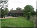
Apple Barn
This large converted barn is beside Water Farm on the A20 Ashford Road. It is the headquarters of KOS Media. This is a local newspaper and internet publishing company. In 2002, it started with the popular Kent on Sunday free paper (hence KOS). It then added Kent on Saturday. It is currently producing free papers for local Kent areas, funded by selling the Kent on Sunday and Kent on Saturday. For more details see http://www.kentnews.co.uk/
Image: © David Anstiss
Taken: 8 Aug 2009
0.23 miles