IMAGES TAKEN NEAR TO
Church Road, ASHFORD, TN25 6SB
Introduction
This page details the photographs taken nearby to Church Road, TN25 6SB by members of the Geograph project.
The Geograph project started in 2005 with the aim of publishing, organising and preserving representative images for every square kilometre of Great Britain, Ireland and the Isle of Man.

There are currently over 7.5m images from over14,400 individuals and you can help contribute to the project by visiting https://www.geograph.org.uk
Image Map
Images are licensed for reuse under creativecommons.org/licenses/by-sa/2.0
Notes
- Clicking on the map will re-center to the selected point.
- The higher the marker number, the further away the image location is from the centre of the postcode.
Image Listing (7 Images Found)
Images are licensed for reuse under creativecommons.org/licenses/by-sa/2.0
Image
Details
Distance
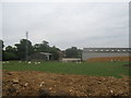
1
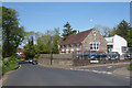
Smeeth County Primary School
On Church Road; Caroland Close to the right.
Image: © Oast House Archive
Taken: 14 May 2010
0.04 miles
2
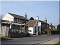
The Blue Anchor Public house Brabourne Lees
Image: © D-G-Seamon
Taken: 13 Apr 2007
0.10 miles
5
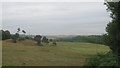
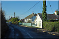
View from Scott's Hall Plantation
Looking eastwards along a footpath towards Fishpond Wood.
Image: © David Anstiss
Taken: 25 Jul 2010
0.18 miles
6
Mobile Phone mast in Walnut Tree Farm
As seen from a footpath leading around the farm from Church Road to Scott's Hall Plantation.
Image: © David Anstiss
Taken: 25 Jul 2010
0.19 miles
7
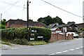
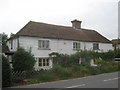
Smeeth, Woolpack Hill: 'Katoomba' and 'Cedar Lodge'
Image: © Michael Garlick
Taken: 29 Aug 2024
0.23 miles