IMAGES TAKEN NEAR TO
Lees Road, ASHFORD, TN25 6RP
Introduction
This page details the photographs taken nearby to Lees Road, TN25 6RP by members of the Geograph project.
The Geograph project started in 2005 with the aim of publishing, organising and preserving representative images for every square kilometre of Great Britain, Ireland and the Isle of Man.

There are currently over 7.5m images from over14,400 individuals and you can help contribute to the project by visiting https://www.geograph.org.uk
Image Map (Loading...)


Getting Data...Please wait
Leaflet Map data © OpenStreetMap
Images are licensed for reuse under creativecommons.org/licenses/by-sa/2.0
Notes
- Clicking on the map will re-center to the selected point.
- The higher the marker number, the further away the image location is from the centre of the postcode.
Image Listing (13 Images Found)
Images are licensed for reuse under creativecommons.org/licenses/by-sa/2.0
Image
Details
Distance
1
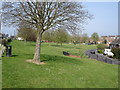
Brabourne Lees village green
View E.N.E. across the green
Image: © D-G-Seamon
Taken: 13 Apr 2007
0.03 miles
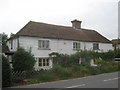
3
Smeeth, Woolpack Hill: 'Katoomba' and 'Cedar Lodge'
Image: © Michael Garlick
Taken: 29 Aug 2024
0.06 miles
4
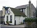
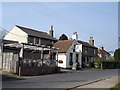
The Blue Anchor on Bridge Street
This quaint little pub was built back in 1786, although it’s only been licensed as a public house since 1815. It became the Blue Anchor at the turn of the century when Thomas Howland, a rope and sail maker took over.
Image: © Nick Smith
Taken: 30 Dec 2007
0.06 miles
5
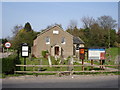
Baptist Church
Brabourne Lees Baptist Church from Plain Road
Image: © D-G-Seamon
Taken: 13 Apr 2007
0.14 miles
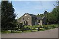
7
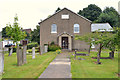
Brabourne Baptist Church, Plain Road, Brabourne Lees
Image: © MrC
Taken: 1 Aug 2016
0.15 miles
8
The Blue Anchor Public house Brabourne Lees
Image: © D-G-Seamon
Taken: 13 Apr 2007
0.16 miles
9
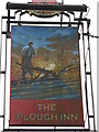
The Plough Inn,Pub Sign, Brabourne Lees
Image: © David Anstiss
Taken: 19 Sep 2010
0.20 miles
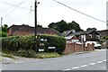
10
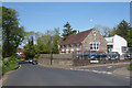
Smeeth County Primary School
On Church Road; Caroland Close to the right.
Image: © Oast House Archive
Taken: 14 May 2010
0.20 miles