IMAGES TAKEN NEAR TO
Mersham, ASHFORD, TN25 6PS
Introduction
This page details the photographs taken nearby to TN25 6PS by members of the Geograph project.
The Geograph project started in 2005 with the aim of publishing, organising and preserving representative images for every square kilometre of Great Britain, Ireland and the Isle of Man.

There are currently over 7.5m images from over14,400 individuals and you can help contribute to the project by visiting https://www.geograph.org.uk
Image Map
Images are licensed for reuse under creativecommons.org/licenses/by-sa/2.0
Notes
- Clicking on the map will re-center to the selected point.
- The higher the marker number, the further away the image location is from the centre of the postcode.
Image Listing (4 Images Found)
Images are licensed for reuse under creativecommons.org/licenses/by-sa/2.0
Image
Details
Distance
1
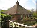
Bockhanger Lodge
Cottage on an access road towards Mersham-le-Hatch (a nearby large country house in a deer park). Reached via an access road through Bockhanger Wood.
Image: © David Anstiss
Taken: 3 May 2010
0.00 miles
2
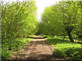
Access track in Bockhanger Wood
This track leads from Bockhanger Lodge, close to Bockham Lane. The track leads through the wood towards the deer park near Mersham-le-Hatch (a nearby large country house).
Image: © David Anstiss
Taken: 3 May 2010
0.05 miles
3
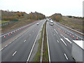
M20 from a new bridge over the motorway
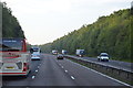
The bridge was distantly visible in this view of the Image The present view shows how the M20 has been realigned, with extra lanes added (here marked with traffic cones) on both sides of the motorway to enable traffic to reach/leave a new junction, which has been named 10A.
This view of the Image shows the new junction.
Image: © John Baker
Taken: 24 Nov 2019
0.09 miles