IMAGES TAKEN NEAR TO
Moorstock Lane, ASHFORD, TN25 6LB
Introduction
This page details the photographs taken nearby to Moorstock Lane, TN25 6LB by members of the Geograph project.
The Geograph project started in 2005 with the aim of publishing, organising and preserving representative images for every square kilometre of Great Britain, Ireland and the Isle of Man.

There are currently over 7.5m images from over14,400 individuals and you can help contribute to the project by visiting https://www.geograph.org.uk
Image Map
Images are licensed for reuse under creativecommons.org/licenses/by-sa/2.0
Notes
- Clicking on the map will re-center to the selected point.
- The higher the marker number, the further away the image location is from the centre of the postcode.
Image Listing (9 Images Found)
Images are licensed for reuse under creativecommons.org/licenses/by-sa/2.0
Image
Details
Distance
1
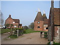
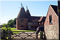
Oast house
Converted Oast at Moorstock.
Image: © Adam Hincks
Taken: 14 Apr 2007
0.06 miles
6
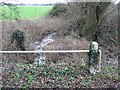
Looking E along the small brook which passes under Moorstock Lane
Image: © Nick Smith
Taken: 30 Dec 2007
0.17 miles
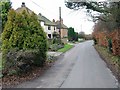
7
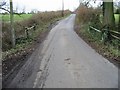
Looking S along Moorstock Lane
From the small brook which the lane crosses.
Image: © Nick Smith
Taken: 30 Dec 2007
0.19 miles
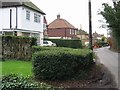
8

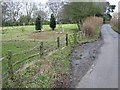
Moorstock Lane
In the foreground the lane crosses a small watercourse flowing to the right to feed some ponds.
Image: © Robin Webster
Taken: 28 Oct 2014
0.19 miles
9

Footpath to Southenay Farm
This path through a flax field (ready to harvest), leads to Southenay Lane and the farm, from Moorstock Lane.
Image: © David Anstiss
Taken: 25 Jul 2010
0.19 miles