IMAGES TAKEN NEAR TO
Swan Lane, ASHFORD, TN25 6HB
Introduction
This page details the photographs taken nearby to Swan Lane, TN25 6HB by members of the Geograph project.
The Geograph project started in 2005 with the aim of publishing, organising and preserving representative images for every square kilometre of Great Britain, Ireland and the Isle of Man.

There are currently over 7.5m images from over14,400 individuals and you can help contribute to the project by visiting https://www.geograph.org.uk
Image Map
Images are licensed for reuse under creativecommons.org/licenses/by-sa/2.0
Notes
- Clicking on the map will re-center to the selected point.
- The higher the marker number, the further away the image location is from the centre of the postcode.
Image Listing (4 Images Found)
Images are licensed for reuse under creativecommons.org/licenses/by-sa/2.0
Image
Details
Distance
1
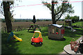
Rear of Lourds Close Sellindge looking S towards the M20
Image: © Peter Skynner
Taken: 9 May 2008
0.07 miles
2
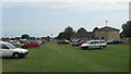
Sellindge Sports Club Saturday afternoon bootfair
This sports club (seen on the right) has an occasional bootfair in the sports ground. Access is from Swan Lane, behind the club.
Image: © David Anstiss
Taken: 8 Aug 2009
0.07 miles
3
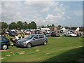
Saturday afternoon bootfair in Sellindge
Sellindge Sports Club has an occasional Saturday afternoon bootfair. Seen from the sports club which sells teas, coffees and sandwiches for vendors and buyers.
Image: © David Anstiss
Taken: 8 Aug 2009
0.10 miles
4
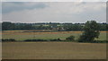
View of the North Downs - Seen from Sellindge
This rural view is seen from Sellindge Sports Club field on Swan Lane.
Image: © David Anstiss
Taken: 8 Aug 2009
0.16 miles