IMAGES TAKEN NEAR TO
St. Marys Road, ASHFORD, TN25 6FT
Introduction
This page details the photographs taken nearby to St. Marys Road, TN25 6FT by members of the Geograph project.
The Geograph project started in 2005 with the aim of publishing, organising and preserving representative images for every square kilometre of Great Britain, Ireland and the Isle of Man.

There are currently over 7.5m images from over14,400 individuals and you can help contribute to the project by visiting https://www.geograph.org.uk
Image Map (Loading...)


Getting Data...Please wait
Leaflet Map data © OpenStreetMap
Images are licensed for reuse under creativecommons.org/licenses/by-sa/2.0
Notes
- Clicking on the map will re-center to the selected point.
- The higher the marker number, the further away the image location is from the centre of the postcode.
Image Listing (57 Images Found)
Images are licensed for reuse under creativecommons.org/licenses/by-sa/2.0
Image
Details
Distance
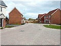
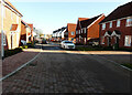
1
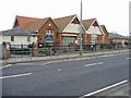
St Marys Road
The road leads to St Katherines Crescent.
Image: © John Baker
Taken: 29 May 2022
0.02 miles
2
St Marys Road
This view shows the temporary end of Image in October 2021.
Image: © John Baker
Taken: 29 May 2022
0.03 miles
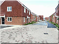
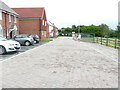
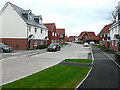
3
St Marys Road
Planning permission has been approved, with conditions, by Folkestone and Hythe District Council under application number Y14/0873/SH for a “hybrid application for the redevelopment of land between the A20 and M20 at Sellindge. Application for outline permission (with all matters reserved except access) comprising of 200 dwellings, local mixed use centre containing parish offices (sui generis up to 100m2), and associated storage (sui generis up to 100m2, 40m2 as closed storage and 60m2 as secure outdoor storage) commercial floorspace (A1/A3/A5 uses up to 200m2) together with access form the A20, associated roads, parking, earthworks, open space including attenuation features and landscaping. Full application comprising 50 dwellings, village green and play equipment, access from the A20, associated roads, community car parking, earthworks, open space including attenuation features and landscaping".
The development has been named The Lees.
Image: © John Baker
Taken: 24 Oct 2021
0.03 miles
4
St Katherines Crescent
Planning permission has been approved, with conditions, by Folkestone and Hythe District Council under application number Y14/0873/SH for a “hybrid application for the redevelopment of land between the A20 and M20 at Sellindge. Application for outline permission (with all matters reserved except access) comprising of 200 dwellings, local mixed use centre containing parish offices (sui generis up to 100m2), and associated storage (sui generis up to 100m2, 40m2 as closed storage and 60m2 as secure outdoor storage) commercial floorspace (A1/A3/A5 uses up to 200m2) together with access form the A20, associated roads, parking, earthworks, open space including attenuation features and landscaping. Full application comprising 50 dwellings, village green and play equipment, access from the A20, associated roads, community car parking, earthworks, open space including attenuation features and landscaping".
Image: © John Baker
Taken: 24 Oct 2021
0.05 miles
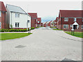
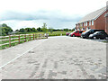
5
St Marys Road
St Marys Road terminates in a cul-de-sac.
Image: © John Baker
Taken: 29 May 2022
0.05 miles
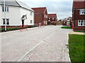
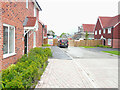
6
St Marys Road
St Marys Road terminates in a cul-de-sac.
Image: © John Baker
Taken: 29 May 2022
0.06 miles
7
St Katherines Crescent
The view shows the temporary end of Image in October 2021.
Image: © John Baker
Taken: 29 May 2022
0.06 miles
8
St Katherines Crescent
A similar view of Image before the temporary fence was removed.
Image: © John Baker
Taken: 22 Nov 2022
0.07 miles
9
St Katherines Crescent
Planning permission has been approved, with conditions, by Folkestone and Hythe District Council under application number Y14/0873/SH for a “hybrid application for the redevelopment of land between the A20 and M20 at Sellindge. Application for outline permission (with all matters reserved except access) comprising of 200 dwellings, local mixed use centre containing parish offices (sui generis up to 100m2), and associated storage (sui generis up to 100m2, 40m2 as closed storage and 60m2 as secure outdoor storage) commercial floorspace (A1/A3/A5 uses up to 200m2) together with access form the A20, associated roads, parking, earthworks, open space including attenuation features and landscaping. Full application comprising 50 dwellings, village green and play equipment, access from the A20, associated roads, community car parking, earthworks, open space including attenuation features and landscaping".
Image: © John Baker
Taken: 24 Oct 2021
0.07 miles