IMAGES TAKEN NEAR TO
Herringe Farm Close, ASHFORD, TN25 6FL
Introduction
This page details the photographs taken nearby to Herringe Farm Close, TN25 6FL by members of the Geograph project.
The Geograph project started in 2005 with the aim of publishing, organising and preserving representative images for every square kilometre of Great Britain, Ireland and the Isle of Man.

There are currently over 7.5m images from over14,400 individuals and you can help contribute to the project by visiting https://www.geograph.org.uk
Image Map
Images are licensed for reuse under creativecommons.org/licenses/by-sa/2.0
Notes
- Clicking on the map will re-center to the selected point.
- The higher the marker number, the further away the image location is from the centre of the postcode.
Image Listing (54 Images Found)
Images are licensed for reuse under creativecommons.org/licenses/by-sa/2.0
Image
Details
Distance
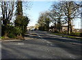
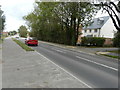
1
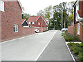
Herringe Farm Close
Planning permission has been approved, with conditions, by Folkestone and Hythe District Council under application number Y14/0873/SH for a “hybrid application for the redevelopment of land between the A20 and M20 at Sellindge. Application for outline permission (with all matters reserved except access) comprising of 200 dwellings, local mixed use centre containing parish offices (sui generis up to 100m2), and associated storage (sui generis up to 100m2, 40m2 as closed storage and 60m2 as secure outdoor storage) commercial floorspace (A1/A3/A5 uses up to 200m2) together with access form the A20, associated roads, parking, earthworks, open space including attenuation features and landscaping. Full application comprising 50 dwellings, village green and play equipment, access from the A20, associated roads, community car parking, earthworks, open space including attenuation features and landscaping".
Image: © John Baker
Taken: 24 Oct 2021
0.00 miles
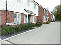
2
Housing development
Planning permission has been approved, with conditions, by Folkestone and Hythe District Council under application number Y14/0873/SH for a “hybrid application for the redevelopment of land between the A20 and M20 at Sellindge. Application for outline permission (with all matters reserved except access) comprising of 200 dwellings, local mixed use centre containing parish offices (sui generis up to 100m2), and associated storage (sui generis up to 100m2, 40m2 as closed storage and 60m2 as secure outdoor storage) commercial floorspace (A1/A3/A5 uses up to 200m2) together with access form the A20, associated roads, parking, earthworks, open space including attenuation features and landscaping. Full application comprising 50 dwellings, village green and play equipment, access from the A20, associated roads, community car parking, earthworks, open space including attenuation features and landscaping".
This view of the Image shows the road (after completion, it was named Image), in this view, from another angle. Both were taken from Bulls Lane.
Image: © John Baker
Taken: 23 Aug 2020
0.01 miles
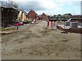
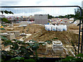
3
Housing development
Planning permission has been approved, with conditions, by Folkestone and Hythe District Council under application number Y14/0873/SH for a “hybrid application for the redevelopment of land between the A20 and M20 at Sellindge. Application for outline permission (with all matters reserved except access) comprising of 200 dwellings, local mixed use centre containing parish offices (sui generis up to 100m2), and associated storage (sui generis up to 100m2, 40m2 as closed storage and 60m2 as secure outdoor storage) commercial floorspace (A1/A3/A5 uses up to 200m2) together with access form the A20, associated roads, parking, earthworks, open space including attenuation features and landscaping. Full application comprising 50 dwellings, village green and play equipment, access from the A20, associated roads, community car parking, earthworks, open space including attenuation features and landscaping".
This view of the Image was also taken from Bulls Lane, from the same location as this photograph.
Image: © John Baker
Taken: 23 Mar 2020
0.02 miles
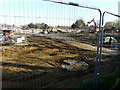
4
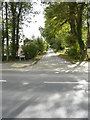
Bulls Lane
Houses are being built on land to the left of the lane. It will be interesting to see how this view has changed, once the development has been completed.
Image: © John Baker
Taken: 23 Aug 2020
0.02 miles
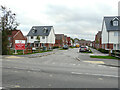
5
Housing development, Ashford Road
Planning permission has been approved, with conditions, by Folkestone and Hythe District Council under application number Y14/0873/SH for a “hybrid application for the redevelopment of land between the A20 and M20 at Sellindge. Application for outline permission (with all matters reserved except access) comprising of 200 dwellings, local mixed use centre containing parish offices (sui generis up to 100m2), and associated storage (sui generis up to 100m2, 40m2 as closed storage and 60m2 as secure outdoor storage) commercial floorspace (A1/A3/A5 uses up to 200m2) together with access form the A20, associated roads, parking, earthworks, open space including attenuation features and landscaping. Full application comprising 50 dwellings, village green and play equipment, access from the A20, associated roads, community car parking, earthworks, open space including attenuation features and landscaping".
The development is a continuation of Image
Image: © John Baker
Taken: 23 Mar 2020
0.02 miles
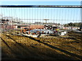
6
Colemans Row
Planning permission has been approved, with conditions, by Folkestone and Hythe District Council under application number Y14/0873/SH for a “hybrid application for the redevelopment of land between the A20 and M20 at Sellindge. Application for outline permission (with all matters reserved except access) comprising of 200 dwellings, local mixed use centre containing parish offices (sui generis up to 100m2), and associated storage (sui generis up to 100m2, 40m2 as closed storage and 60m2 as secure outdoor storage) commercial floorspace (A1/A3/A5 uses up to 200m2) together with access form the A20, associated roads, parking, earthworks, open space including attenuation features and landscaping. Full application comprising 50 dwellings, village green and play equipment, access from the A20, associated roads, community car parking, earthworks, open space including attenuation features and landscaping".
Image: © John Baker
Taken: 24 Oct 2021
0.03 miles
7
Housing development
Planning permission has been approved, with conditions, by Folkestone and Hythe District Council under application number Y14/0873/SH for a “hybrid application for the redevelopment of land between the A20 and M20 at Sellindge. Application for outline permission (with all matters reserved except access) comprising of 200 dwellings, local mixed use centre containing parish offices (sui generis up to 100m2), and associated storage (sui generis up to 100m2, 40m2 as closed storage and 60m2 as secure outdoor storage) commercial floorspace (A1/A3/A5 uses up to 200m2) together with access form the A20, associated roads, parking, earthworks, open space including attenuation features and landscaping. Full application comprising 50 dwellings, village green and play equipment, access from the A20, associated roads, community car parking, earthworks, open space including attenuation features and landscaping".
This view of the Image was also taken from Bulls Lane but further along the lane away from Ashford Road.
Image: © John Baker
Taken: 23 Mar 2020
0.03 miles
8
St Kathernes Crescent
Planning permission has been approved, with conditions, by Folkestone and Hythe District Council under application number Y14/0873/SH for a “hybrid application for the redevelopment of land between the A20 and M20 at Sellindge. Application for outline permission (with all matters reserved except access) comprising of 200 dwellings, local mixed use centre containing parish offices (sui generis up to 100m2), and associated storage (sui generis up to 100m2, 40m2 as closed storage and 60m2 as secure outdoor storage) commercial floorspace (A1/A3/A5 uses up to 200m2) together with access form the A20, associated roads, parking, earthworks, open space including attenuation features and landscaping. Full application comprising 50 dwellings, village green and play equipment, access from the A20, associated roads, community car parking, earthworks, open space including attenuation features and landscaping".
On the road sign the road is spelt Kathernes while on the map it is spelt Katherines. This was Image in August 2020.
Image: © John Baker
Taken: 24 Oct 2021
0.03 miles
9
Housing development, Ashford Road
Planning permission has been approved, with conditions, by Folkestone and Hythe District Council under application number Y14/0873/SH for a “hybrid application for the redevelopment of land between the A20 and M20 at Sellindge. Application for outline permission (with all matters reserved except access) comprising of 200 dwellings, local mixed use centre containing parish offices (sui generis up to 100m2), and associated storage (sui generis up to 100m2, 40m2 as closed storage and 60m2 as secure outdoor storage) commercial floorspace (A1/A3/A5 uses up to 200m2) together with access form the A20, associated roads, parking, earthworks, open space including attenuation features and landscaping. Full application comprising 50 dwellings, village green and play equipment, access from the A20, associated roads, community car parking, earthworks, open space including attenuation features and landscaping".
This was Image, in March 2020, from the junction with Moorstock Lane.
Image: © John Baker
Taken: 23 Aug 2020
0.03 miles
10
Housing development
Planning permission has been approved, with conditions, by Folkestone and Hythe District Council under application number Y14/0873/SH for a “hybrid application for the redevelopment of land between the A20 and M20 at Sellindge. Application for outline permission (with all matters reserved except access) comprising of 200 dwellings, local mixed use centre containing parish offices (sui generis up to 100m2), and associated storage (sui generis up to 100m2, 40m2 as closed storage and 60m2 as secure outdoor storage) commercial floorspace (A1/A3/A5 uses up to 200m2) together with access form the A20, associated roads, parking, earthworks, open space including attenuation features and landscaping. Full application comprising 50 dwellings, village green and play equipment, access from the A20, associated roads, community car parking, earthworks, open space including attenuation features and landscaping".
This view of the Image shows the site, in this view, from another angle. Both were taken from Bulls Lane.
Image: © John Baker
Taken: 23 Aug 2020
0.04 miles