IMAGES TAKEN NEAR TO
Maple Crescent, ASHFORD, TN25 6FA
Introduction
This page details the photographs taken nearby to Maple Crescent, TN25 6FA by members of the Geograph project.
The Geograph project started in 2005 with the aim of publishing, organising and preserving representative images for every square kilometre of Great Britain, Ireland and the Isle of Man.

There are currently over 7.5m images from over14,400 individuals and you can help contribute to the project by visiting https://www.geograph.org.uk
Image Map
Images are licensed for reuse under creativecommons.org/licenses/by-sa/2.0
Notes
- Clicking on the map will re-center to the selected point.
- The higher the marker number, the further away the image location is from the centre of the postcode.
Image Listing (11 Images Found)
Images are licensed for reuse under creativecommons.org/licenses/by-sa/2.0
Image
Details
Distance
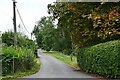
1
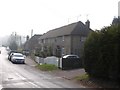
Cottages
These residential cottages used to be a hospital during the Napoleonic War for French prisoners of war.
Image: © Adam Hincks
Taken: 14 Apr 2007
0.12 miles
3
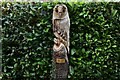
Smeeth: Owl carved from a tree stump using a chainsaw
Image: © Michael Garlick
Taken: 29 Aug 2024
0.16 miles
4
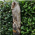
Smeeth: Owl carved from a tree stump using a chainsaw
Image: © Michael Garlick
Taken: 29 Aug 2024
0.16 miles
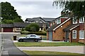
6
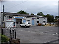
Garage
Garage forecourt east from Plain Road near Lilyvale
Image: © D-G-Seamon
Taken: 26 May 2007
0.20 miles
7
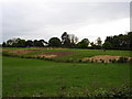
Paddocks
Paddocks across field from Plain Road
Image: © D-G-Seamon
Taken: 26 May 2007
0.21 miles
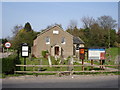
9
Brabourne Baptist Church, Plain Road, Brabourne Lees
Image: © MrC
Taken: 1 Aug 2016
0.23 miles
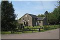
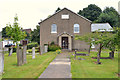
10
Baptist Church
Brabourne Lees Baptist Church from Plain Road
Image: © D-G-Seamon
Taken: 13 Apr 2007
0.25 miles