IMAGES TAKEN NEAR TO
Hampton Lane, ASHFORD, TN25 5PN
Introduction
This page details the photographs taken nearby to Hampton Lane, TN25 5PN by members of the Geograph project.
The Geograph project started in 2005 with the aim of publishing, organising and preserving representative images for every square kilometre of Great Britain, Ireland and the Isle of Man.

There are currently over 7.5m images from over14,400 individuals and you can help contribute to the project by visiting https://www.geograph.org.uk
Image Map
Images are licensed for reuse under creativecommons.org/licenses/by-sa/2.0
Notes
- Clicking on the map will re-center to the selected point.
- The higher the marker number, the further away the image location is from the centre of the postcode.
Image Listing (22 Images Found)
Images are licensed for reuse under creativecommons.org/licenses/by-sa/2.0
Image
Details
Distance
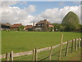
1
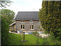
Wood Smoke
Modern timberframed and cedar panelled house on Hampton Lane.
Image: © David Anstiss
Taken: 3 May 2010
0.00 miles
4
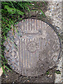
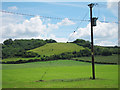
Hepworth Manhole
Near Hampton Farm by Hampton Lane.
Image: © Oast House Archive
Taken: 24 Jun 2011
0.05 miles
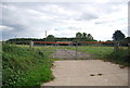
7
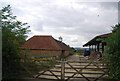
Hampton Farm
As seen by a footpath from Troy Town Lane towards Hampton Lane.
Image: © David Anstiss
Taken: 3 May 2010
0.07 miles
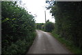
9
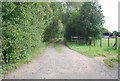
Access road to Beddlestone Farm
This farm road leads from Hampton Lane. A footpath also follows the route to the farm and onwards to Cadman's Wood on Bulltown Lane.
Image: © David Anstiss
Taken: 3 May 2010
0.11 miles