IMAGES TAKEN NEAR TO
Hinxhill, ASHFORD, TN25 5NS
Introduction
This page details the photographs taken nearby to TN25 5NS by members of the Geograph project.
The Geograph project started in 2005 with the aim of publishing, organising and preserving representative images for every square kilometre of Great Britain, Ireland and the Isle of Man.

There are currently over 7.5m images from over14,400 individuals and you can help contribute to the project by visiting https://www.geograph.org.uk
Image Map (Loading...)


Getting Data...Please wait
Leaflet Map data © OpenStreetMap
Images are licensed for reuse under creativecommons.org/licenses/by-sa/2.0
Notes
- Clicking on the map will re-center to the selected point.
- The higher the marker number, the further away the image location is from the centre of the postcode.
Image Listing (6 Images Found)
Images are licensed for reuse under creativecommons.org/licenses/by-sa/2.0
Image
Details
Distance
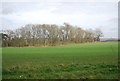
1
Pheasant Cottage
Pheasant Cottage near Goodcheap Farm, north from Goodcheap Lane
Image: © D-G-Seamon
Taken: 24 Apr 2007
0.03 miles
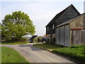
2
Goodcheap Farm
Looking south east from Goodcheap Lane to Goodcheap Farm
Image: © D-G-Seamon
Taken: 24 Apr 2007
0.07 miles
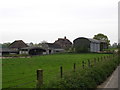
3

Goodcheap Farm
As seen from a footpath from Oxenturn Road near Sillibourne Farm, leading towards Goodcheap Lane.
Image: © David Anstiss
Taken: 3 May 2010
0.07 miles
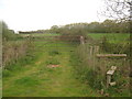
4

Footpath crosses Goodcheap Lane
Goodcheap Lane leads towards Goodcheap Farm (in the background) then the lane leads to Hinxhill. A footpath leads left towards Oxentrun Road near Sillibourne Farm, or right towards Blackwall Road near Goose Green.
Image: © David Anstiss
Taken: 3 May 2010
0.11 miles
5
Gate near Goodcheap Farm
This gate is on a path from Oxenturn Road near Sillibourne Farm, towards Goodcheap Lane.
Image: © David Anstiss
Taken: 3 May 2010
0.16 miles