IMAGES TAKEN NEAR TO
Hinxhill, ASHFORD, TN25 5NP
Introduction
This page details the photographs taken nearby to TN25 5NP by members of the Geograph project.
The Geograph project started in 2005 with the aim of publishing, organising and preserving representative images for every square kilometre of Great Britain, Ireland and the Isle of Man.

There are currently over 7.5m images from over14,400 individuals and you can help contribute to the project by visiting https://www.geograph.org.uk
Image Map
Images are licensed for reuse under creativecommons.org/licenses/by-sa/2.0
Notes
- Clicking on the map will re-center to the selected point.
- The higher the marker number, the further away the image location is from the centre of the postcode.
Image Listing (5 Images Found)
Images are licensed for reuse under creativecommons.org/licenses/by-sa/2.0
Image
Details
Distance
1
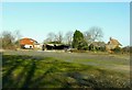
Ouseley Farm, Hinxhill
Situated just off Hinxhill Road. The farm buildings are in a very rundown state, especially the barn, beyond and slightly to the left of the house, whose roof has been stripped of its tiles.
Image: © John Baker
Taken: 15 Jan 2012
0.02 miles
4
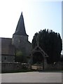
Hinxhill Church
The church is located within the small rural village of Hinxhill just off Hinxhill Road, between the village of Wye and Ashford. The church is surrounded by buildings of the Hinxhill Estate. The picture shows the entrance and the tower which can be seen from Hinxhill Road as you drive along.
Image: © Adam Hincks
Taken: 14 Apr 2007
0.24 miles
5
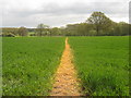
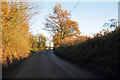
Footpath towards Alders
A path leads from Hinxhill Road, near Hinxhill across a field to block of trees and then heads towards Nackholt Wood.
Image: © David Anstiss
Taken: 3 May 2010
0.25 miles