IMAGES TAKEN NEAR TO
Manor Pound Lane, ASHFORD, TN25 5LG
Introduction
This page details the photographs taken nearby to Manor Pound Lane, TN25 5LG by members of the Geograph project.
The Geograph project started in 2005 with the aim of publishing, organising and preserving representative images for every square kilometre of Great Britain, Ireland and the Isle of Man.

There are currently over 7.5m images from over14,400 individuals and you can help contribute to the project by visiting https://www.geograph.org.uk
Image Map (Loading...)


Getting Data...Please wait
Leaflet Map data © OpenStreetMap
Images are licensed for reuse under creativecommons.org/licenses/by-sa/2.0
Notes
- Clicking on the map will re-center to the selected point.
- The higher the marker number, the further away the image location is from the centre of the postcode.
Image Listing (6 Images Found)
Images are licensed for reuse under creativecommons.org/licenses/by-sa/2.0
Image
Details
Distance
2
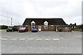
Brabourne Lees & Smeeth Village Hall
The local village hall providing a venue for the local community functions.
Image: © Adam Hincks
Taken: 14 Apr 2007
0.06 miles
3
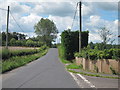
Lees Road
Towards Brabourne Lees.
Image: © Oast House Archive
Taken: 24 Jun 2011
0.08 miles
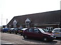
4
Houses at Birchholt Forstal
A large tree is seen here in satellite images, it looks to have been replaced with this new tree recently.
Image: © Oast House Archive
Taken: 24 Jun 2011
0.08 miles
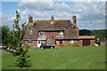
5
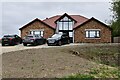
West Brabourne: Newly built bungalow
Image: © Michael Garlick
Taken: 29 Aug 2024
0.16 miles
6
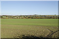
Fields near Bircholt Forstal
With the South Downs in the distance.
Image: © Julian P Guffogg
Taken: 10 Nov 2013
0.24 miles