IMAGES TAKEN NEAR TO
Hastingleigh, ASHFORD, TN25 5HZ
Introduction
This page details the photographs taken nearby to TN25 5HZ by members of the Geograph project.
The Geograph project started in 2005 with the aim of publishing, organising and preserving representative images for every square kilometre of Great Britain, Ireland and the Isle of Man.

There are currently over 7.5m images from over14,400 individuals and you can help contribute to the project by visiting https://www.geograph.org.uk
Image Map
Images are licensed for reuse under creativecommons.org/licenses/by-sa/2.0
Notes
- Clicking on the map will re-center to the selected point.
- The higher the marker number, the further away the image location is from the centre of the postcode.
Image Listing (9 Images Found)
Images are licensed for reuse under creativecommons.org/licenses/by-sa/2.0
Image
Details
Distance
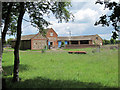
1
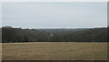
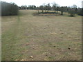
West Down
Moorlands Wood to left, Maines Wood to right.
Image: © Oast House Archive
Taken: 24 Jun 2011
0.12 miles
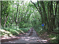
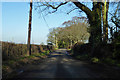
2
Footpath to Hastingleigh
A footpath (No.AE227) leads of an unnamed lane to Hastingleigh. The lane on the left leads to West Down.
Image: © David Anstiss
Taken: 21 Mar 2010
0.13 miles
3
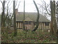
Moorlands House
On Wood's Hill. Moorlands Wood is in the background.
Image: © David Anstiss
Taken: 21 Mar 2010
0.16 miles
4
Three Woods near Hastingleigh
Seen from a footpath (No.AE227) towards The Street, Hastingleigh.
Shrub's Wood is on the left, Bow Lease is in the middle and Elvington Lease is on the right.
Image: © David Anstiss
Taken: 21 Mar 2010
0.17 miles
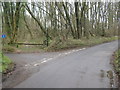
5
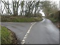
Lane junction near Hastingleigh
Wood Hill leads from Waltham straight on to Brabourne Road. An unnamed lane heads left towards The Street, Hastingleigh.
Image: © David Anstiss
Taken: 21 Mar 2010
0.18 miles
7
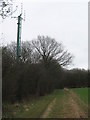
Mobile Mast in Newlands Wood
A footpath (No.AE226) leads from Smeed Farm towards Woods Hill lane.
Image: © David Anstiss
Taken: 21 Mar 2010
0.22 miles
8
Footpath to Hastingleigh (2)
This path (no.AE227) leads from Haines Wood through a valley towards The Street.
Image: © David Anstiss
Taken: 21 Mar 2010
0.23 miles