IMAGES TAKEN NEAR TO
Bramble Lane, ASHFORD, TN25 5EH
Introduction
This page details the photographs taken nearby to Bramble Lane, TN25 5EH by members of the Geograph project.
The Geograph project started in 2005 with the aim of publishing, organising and preserving representative images for every square kilometre of Great Britain, Ireland and the Isle of Man.

There are currently over 7.5m images from over14,400 individuals and you can help contribute to the project by visiting https://www.geograph.org.uk
Image Map (Loading...)


Getting Data...Please wait
Leaflet Map data © OpenStreetMap
Images are licensed for reuse under creativecommons.org/licenses/by-sa/2.0
Notes
- Clicking on the map will re-center to the selected point.
- The higher the marker number, the further away the image location is from the centre of the postcode.
Image Listing (194 Images Found)
Images are licensed for reuse under creativecommons.org/licenses/by-sa/2.0
Image
Details
Distance

2
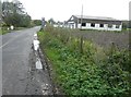
Wye Motors, Bramble Lane
Fuel is always more costly at this outlet. In this view, unleaded is being sold for 141.0/litre, while diesel for 147.0/litre.
Image: © John Baker
Taken: 20 Oct 2013
0.02 miles
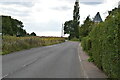
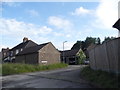
4
New houses along Bramble Lane
Austen House is that with dormer windows.
Image: © John Baker
Taken: 20 Oct 2013
0.07 miles
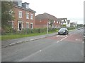
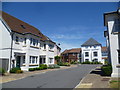
5
Havillands Place, Wye
Prince Charles' housing project at Poundbury in Dorset has a lot to answer for as so many modern estates try to copy it. This is Havillands Place just west of Wye station, and just off Bramble Lane.
Image: © Marathon
Taken: 10 Jul 2015
0.08 miles
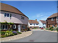
7
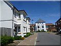
Havillands Place at Wye
Prince Charles' housing project at Poundbury in Dorset has a lot to answer for as so many modern estates try to copy it. This is Havillands Place just west of Wye station, seen from Bramble Lane.
Image: © Marathon
Taken: 10 Jul 2015
0.09 miles
8
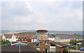
New housing development in Wye
The central block of flats has a distinctive shape. Nicknamed the 'baked bean can' locally, the building is circular with an angled roof. This view is from the railway station footbridge across the industrial estate, with the outstandingly beautiful North Downs in the background.
Image: © Mike Sharpe
Taken: 17 Sep 2008
0.09 miles
9
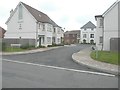
Havillands Place
Seen from Bramble Lane. This view is looking east Image when this part of the estate was still under construction.
The estate was constructed on a depot, of about six acres, that was originally built as an Aviation Fuel (or Air Force) Distribution Depot in 1943 by Shell Mex & BP and operated by the British Pipelines Agency up until its closure in 1979. It was constructed with four 500 semi-buried rectangular protected main storage tanks and four 30’ x 9’ tanks for storing up to 160 tons of lubricating oils. The road gantry had four bays for loading and two for offloading. A siding gantry at Wye railway station had provision to load twelve wagons simultaneously with white products or to offload five wagons and load seven. It was for a short period connected to the PLUTO pipeline supplying the PLUTO (Pipe Line under the Ocean) facilities at Dungeness. The depot was sold by auction in 2001 http://sussexhistoryforum.co.uk/index.php?topic=5023.0;wap2
Image: © John Baker
Taken: 20 Oct 2013
0.09 miles
10
Havillands Place at Wye
Prince Charles' housing project at Poundbury in Dorset has a lot to answer for as so many modern estates try to copy it. This is Havillands Place just west of Wye station, seen from Bramble Lane.
Image: © Marathon
Taken: 10 Jul 2015
0.09 miles