IMAGES TAKEN NEAR TO
Upper Bridge Street, ASHFORD, TN25 5AW
Introduction
This page details the photographs taken nearby to Upper Bridge Street, TN25 5AW by members of the Geograph project.
The Geograph project started in 2005 with the aim of publishing, organising and preserving representative images for every square kilometre of Great Britain, Ireland and the Isle of Man.

There are currently over 7.5m images from over14,400 individuals and you can help contribute to the project by visiting https://www.geograph.org.uk
Image Map (Loading...)


Getting Data...Please wait
Leaflet Map data © OpenStreetMap
Images are licensed for reuse under creativecommons.org/licenses/by-sa/2.0
Notes
- Clicking on the map will re-center to the selected point.
- The higher the marker number, the further away the image location is from the centre of the postcode.
Image Listing (320 Images Found)
Images are licensed for reuse under creativecommons.org/licenses/by-sa/2.0
Image
Details
Distance
5
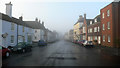
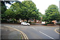
Wye in Kent
Bridge Street in Wye, early autumn morning.
Image: © geo sharples
Taken: 3 Oct 2006
0.03 miles
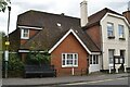
9
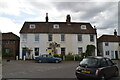
42, Upper Bridge Street
Planning permission has been granted by Ashford Borough Council under application number 14/01319/AS for the “erection of a single storey extension to rear, with front and rear dormer windows and side roof-light to facilitate loft conversion”.
Image: © John Baker
Taken: 27 Dec 2015
0.05 miles
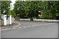
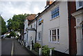
10
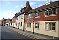
7, Upper Bridge St
Grade II listed. http://www.britishlistedbuildings.co.uk/en-412662-7-upper-bridge-street-wye-with-hinxhill-
Image: © N Chadwick
Taken: 31 Aug 2014
0.05 miles