IMAGES TAKEN NEAR TO
Pilgrims Way, ASHFORD, TN25 4NQ
Introduction
This page details the photographs taken nearby to Pilgrims Way, TN25 4NQ by members of the Geograph project.
The Geograph project started in 2005 with the aim of publishing, organising and preserving representative images for every square kilometre of Great Britain, Ireland and the Isle of Man.

There are currently over 7.5m images from over14,400 individuals and you can help contribute to the project by visiting https://www.geograph.org.uk
Image Map
Images are licensed for reuse under creativecommons.org/licenses/by-sa/2.0
Notes
- Clicking on the map will re-center to the selected point.
- The higher the marker number, the further away the image location is from the centre of the postcode.
Image Listing (18 Images Found)
Images are licensed for reuse under creativecommons.org/licenses/by-sa/2.0
Image
Details
Distance
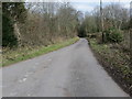
2
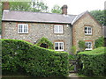
Flint Cottage
On Pilgrims Way road, near Dunn Street. The North Downs Way (long distance footpath) passes this cottage. Appropriate name, many flints in the chalky North Downs.
Image: © David Anstiss
Taken: 28 May 2009
0.06 miles
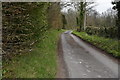
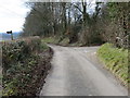
3
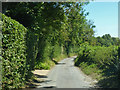
Pilgrims Way
Towards Canterbury from a pilgrim's point of view.
Image: © Robin Webster
Taken: 2 Aug 2018
0.08 miles
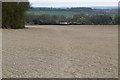
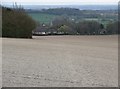
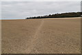
5
Gold Hill at Westwell Downs
Looking north-eastward along the North Downs Way.
Image: © Peter Wood
Taken: 17 Feb 2016
0.09 miles
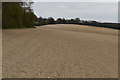
10
Gold Hill at Westwell Downs
Looking south-westward.
Image: © Peter Wood
Taken: 17 Feb 2016
0.15 miles