IMAGES TAKEN NEAR TO
Faversham Road, ASHFORD, TN25 4HL
Introduction
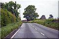
This page details the photographs taken nearby to Faversham Road, TN25 4HL by members of the Geograph project.
The Geograph project started in 2005 with the aim of publishing, organising and preserving representative images for every square kilometre of Great Britain, Ireland and the Isle of Man.

There are currently over 7.5m images from over14,400 individuals and you can help contribute to the project by visiting https://www.geograph.org.uk
Image Map
Images are licensed for reuse under creativecommons.org/licenses/by-sa/2.0
Notes
- Clicking on the map will re-center to the selected point.
- The higher the marker number, the further away the image location is from the centre of the postcode.
Image Listing (2 Images Found)
Images are licensed for reuse under creativecommons.org/licenses/by-sa/2.0
Image
Details
Distance
2
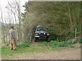
Byway open to all traffic
Tight byway, best to walk on foot first, as not suitable for roofracks. Signs of rabbit warrens in sand, not known if current or historical. Byway has not been maintained but is obviously an ancient part of Brewhouse lane, with ancient vehicular erosion by use.
Image: © Peter
Taken: 11 Apr 2009
0.22 miles