IMAGES TAKEN NEAR TO
Hazel Heights, ASHFORD, TN25 4GF
Introduction
This page details the photographs taken nearby to Hazel Heights, TN25 4GF by members of the Geograph project.
The Geograph project started in 2005 with the aim of publishing, organising and preserving representative images for every square kilometre of Great Britain, Ireland and the Isle of Man.

There are currently over 7.5m images from over14,400 individuals and you can help contribute to the project by visiting https://www.geograph.org.uk
Image Map
Images are licensed for reuse under creativecommons.org/licenses/by-sa/2.0
Notes
- Clicking on the map will re-center to the selected point.
- The higher the marker number, the further away the image location is from the centre of the postcode.
Image Listing (12 Images Found)
Images are licensed for reuse under creativecommons.org/licenses/by-sa/2.0
Image
Details
Distance
4
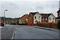
Forest Avenue
The turning on the right is Sun Rise!
Image: © Robin Webster
Taken: 21 Mar 2010
0.16 miles
5
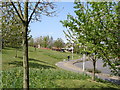
Orchard Heights Estate
Looking north northwest on Orchard Heights Estate
Image: © D-G-Seamon
Taken: 20 Apr 2007
0.18 miles