IMAGES TAKEN NEAR TO
Squids Gate, ASHFORD, TN25 4DR
Introduction
This page details the photographs taken nearby to Squids Gate, TN25 4DR by members of the Geograph project.
The Geograph project started in 2005 with the aim of publishing, organising and preserving representative images for every square kilometre of Great Britain, Ireland and the Isle of Man.

There are currently over 7.5m images from over14,400 individuals and you can help contribute to the project by visiting https://www.geograph.org.uk
Image Map
Images are licensed for reuse under creativecommons.org/licenses/by-sa/2.0
Notes
- Clicking on the map will re-center to the selected point.
- The higher the marker number, the further away the image location is from the centre of the postcode.
Image Listing (12 Images Found)
Images are licensed for reuse under creativecommons.org/licenses/by-sa/2.0
Image
Details
Distance
1
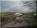
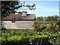
Squids Gate Farm
You can just make out the complex roof of this farmhouse behind the hedge. Taken from Squids Gate Lane.
Image: © Penny Mayes
Taken: 20 Sep 2006
0.01 miles
2
Squids Gate Farm
Off Squids Gate Lane.
Image: © Oast House Archive
Taken: 21 Mar 2010
0.09 miles
3
Longbeech Wood at Squids Gate
Longbeech Wood is a huge area of woodland on top of the North Downs above Charing, classified by the Forestry Commission as a plantation on an Ancient Woodland Site; it comprises a mixture of species including Sweet Chestnut, Norway Spruce, Corsican Pine and Japanese larch. Planting took place between 1957 and 1989. I have absolutely no idea why this area is called Squids Gate.
Image: © Penny Mayes
Taken: 20 Sep 2006
0.15 miles
4
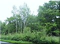
Challock Livery Yard
On Squids Gate Lane, opposite the gliding club http://www.geograph.org.uk/photo/246312 The building in the background is just across the gridline in TQ9849 while the manège is in TQ9749.
Image: © Penny Mayes
Taken: 20 Sep 2006
0.16 miles
5
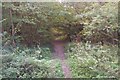
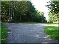
Track into Longbeech Wood
Seen from the A252 Canterbury Road.
Image: © David Anstiss
Taken: 17 Oct 2009
0.18 miles
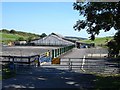
7
Barn at Burnt Oak Farm
North of Squids Gate Lane.
Image: © Penny Mayes
Taken: 20 Sep 2006
0.19 miles
8
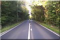
The A252 Canterbury Road
This long straight road leads from Charing Hill towards Challock. Several hollows along the road, make it dangerous to overtake slow moving traffic. It also passes through Longbeech Wood.
Image: © David Anstiss
Taken: 17 Oct 2009
0.20 miles
9
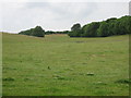
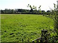
Valley View to Squids Gate Farm
As seen from the footpath near Catsdane Wood.
Image: © David Anstiss
Taken: 28 Jun 2009
0.24 miles
10
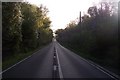
The A252 Canterbury towards Charing
This long straight road leads from Challock towards Charing Hill. Several hollows along the road, make it dangerous to overtake slow moving traffic. It also passes through Longbeech Wood.
Image: © David Anstiss
Taken: 17 Oct 2009
0.24 miles