IMAGES TAKEN NEAR TO
Halls Hole Road, TUNBRIDGE WELLS, TN2 4RD
Introduction
This page details the photographs taken nearby to Halls Hole Road, TN2 4RD by members of the Geograph project.
The Geograph project started in 2005 with the aim of publishing, organising and preserving representative images for every square kilometre of Great Britain, Ireland and the Isle of Man.

There are currently over 7.5m images from over14,400 individuals and you can help contribute to the project by visiting https://www.geograph.org.uk
Image Map
Images are licensed for reuse under creativecommons.org/licenses/by-sa/2.0
Notes
- Clicking on the map will re-center to the selected point.
- The higher the marker number, the further away the image location is from the centre of the postcode.
Image Listing (297 Images Found)
Images are licensed for reuse under creativecommons.org/licenses/by-sa/2.0
Image
Details
Distance
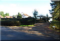
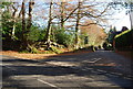
4
View of the Grecian Temple, Dunorlan Park
Seen from Mouseden Farm access road.
Image: © David Anstiss
Taken: 6 Dec 2009
0.06 miles
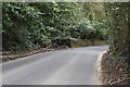
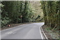
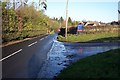
6
Hall's Hole Road
Dunorlan Farm is just ahead, beyond the bend.
Image: © Marathon
Taken: 11 Jul 2020
0.09 miles
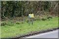
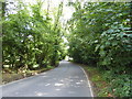
8
Trees at the junction of Halls Hole Rd & Cornford Lane
Image: © N Chadwick
Taken: 22 Nov 2008
0.12 miles
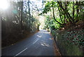
9
Hall Hole Road
This road leads from Hawkenbury to Blackhurst. The junction on the right is the access road to Mouseden Farm.
Image: © David Anstiss
Taken: 6 Dec 2009
0.12 miles
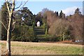
10
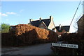
Dunorlan Farm
The building was built in 1861.
Image: © N Chadwick
Taken: 22 Nov 2008
0.12 miles