IMAGES TAKEN NEAR TO
Westway, TUNBRIDGE WELLS, TN2 4EX
Introduction
This page details the photographs taken nearby to Westway, TN2 4EX by members of the Geograph project.
The Geograph project started in 2005 with the aim of publishing, organising and preserving representative images for every square kilometre of Great Britain, Ireland and the Isle of Man.

There are currently over 7.5m images from over14,400 individuals and you can help contribute to the project by visiting https://www.geograph.org.uk
Image Map
Images are licensed for reuse under creativecommons.org/licenses/by-sa/2.0
Notes
- Clicking on the map will re-center to the selected point.
- The higher the marker number, the further away the image location is from the centre of the postcode.
Image Listing (105 Images Found)
Images are licensed for reuse under creativecommons.org/licenses/by-sa/2.0
Image
Details
Distance

2
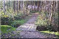
Footbridge near Marshleyharbour Wood
This bridge is on a path from Rowley Hill Road past the wood (on the right) and Lower Green (unseen on the left), heading to the A228 Maidstone Road.
Image: © David Anstiss
Taken: 6 Dec 2009
0.06 miles
3
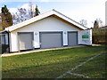
Pembury Athletic Youth Football Club
PAYFC Pavilion located in the Pembury Lower Green recreation ground.
Image: © Chris McAuley
Taken: 15 Dec 2011
0.07 miles

5
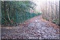
Footpath junction near Westway
A footpath from Rowley Hill Road heads straight on towards the A228 Maidstone Road. Another path heads left to Westway in Pembury. The green fence surrounds the Pembury Scout and Girl Guide Headquarters. Marshleyharbour Wood is on the right.
Image: © David Anstiss
Taken: 6 Dec 2009
0.08 miles
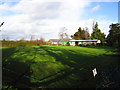
6
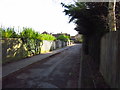
Access Road
Access road from Lower Green Road, to the Lower Green Recreation ground, looking towards Lower Green Road.
Image: © Chris McAuley
Taken: 15 Dec 2011
0.08 miles
7
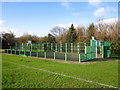
Multi Activity Area
Multi activity, all weather area, located in Lower Green recreation ground.
Image: © Chris McAuley
Taken: 15 Dec 2011
0.09 miles
8
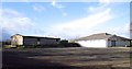
Car Park
Car parking area for Lower Green Recreation ground, the Pembury Bowls Club, building is on the left and the football club pavilion is on the right.
Image: © Chris McAuley
Taken: 15 Dec 2011
0.09 miles
9
Pembury Bowls Club
http://www.pemburybowlsclub.co.uk/
Image: © Chris McAuley
Taken: 15 Dec 2011
0.09 miles
