IMAGES TAKEN NEAR TO
Atkinson Walk, ASHFORD, TN24 9SB
Introduction
This page details the photographs taken nearby to Atkinson Walk, TN24 9SB by members of the Geograph project.
The Geograph project started in 2005 with the aim of publishing, organising and preserving representative images for every square kilometre of Great Britain, Ireland and the Isle of Man.

There are currently over 7.5m images from over14,400 individuals and you can help contribute to the project by visiting https://www.geograph.org.uk
Image Map
Images are licensed for reuse under creativecommons.org/licenses/by-sa/2.0
Notes
- Clicking on the map will re-center to the selected point.
- The higher the marker number, the further away the image location is from the centre of the postcode.
Image Listing (17 Images Found)
Images are licensed for reuse under creativecommons.org/licenses/by-sa/2.0
Image
Details
Distance
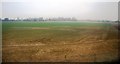
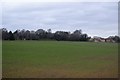
1
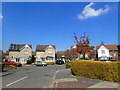
John Badger Close, Kennington, Ashford
This new housing is towards the north-east of the current limit of the built-up area of Ashford.
Image: © Marathon
Taken: 27 Apr 2021
0.07 miles
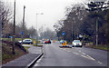
6
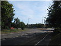
Roundabout at Spearpoint Corner
The A28 Canterbury Road from Canterbury (via Chilham) heads straight on towards Ashford. The A2070 Willesborough Road heads left towards the M20 and Brenzett.
Image: © David Anstiss
Taken: 23 Aug 2009
0.17 miles
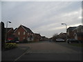
7
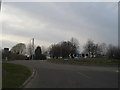
Roundabout at the junction of Willesborough Road and Canterbury Road
Image: © David Howard
Taken: 21 Apr 2013
0.18 miles
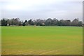
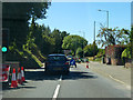
10
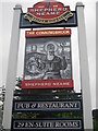
The Conningbrook Pub Sign
At the entrance to the Pub/Restaurant and Hotel carpark on Spearmint Corner Roundabout.
Image: © David Anstiss
Taken: 7 Aug 2010
0.20 miles