IMAGES TAKEN NEAR TO
Park Road, ASHFORD, TN24 9DJ
Introduction
This page details the photographs taken nearby to Park Road, TN24 9DJ by members of the Geograph project.
The Geograph project started in 2005 with the aim of publishing, organising and preserving representative images for every square kilometre of Great Britain, Ireland and the Isle of Man.

There are currently over 7.5m images from over14,400 individuals and you can help contribute to the project by visiting https://www.geograph.org.uk
Image Map
Images are licensed for reuse under creativecommons.org/licenses/by-sa/2.0
Notes
- Clicking on the map will re-center to the selected point.
- The higher the marker number, the further away the image location is from the centre of the postcode.
Image Listing (13 Images Found)
Images are licensed for reuse under creativecommons.org/licenses/by-sa/2.0
Image
Details
Distance
1
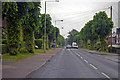
Faversham Road, Kennington, Ashford
Image: © J.Hannan-Briggs
Taken: 26 May 2014
0.03 miles
2
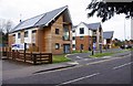
Modern apartments in Faversham Road, Kennington, Ashford, Kent
Modern apartments recently built. The block nearest the camera is Jupiter House. One of the others, probably the one to its right, is called Pluto House. The solar heating panels on the roof of Jupiter House can be seen in this view.
Image: © P L Chadwick
Taken: 31 Mar 2012
0.14 miles
3
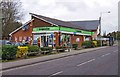
The Co-operative Food, 98 Faversham Road, Kennington, Ashford, Kent
A small supermarket serving the Kennington area of Ashford in Kent.
Image: © P L Chadwick
Taken: 31 Mar 2012
0.15 miles
4
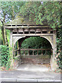
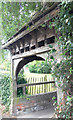
Ashford : Pump House, Kennington
This unusual building in Upper Vicarage Road, Kennington, is shown on OS Maps from the 1930's as the Pump House.
Image: © Chris Morley
Taken: 10 Aug 2008
0.21 miles
5
Ashford : Pump House, Kennington
This unusual building in Upper Vicarage Road, Kennington, is shown on OS Maps from the 1930's as the Pump House.
Image: © Chris Morley
Taken: 10 Aug 2008
0.21 miles
6
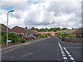
Grasmere Road, Kennington
Looking north west from the junction with Meadowbrook Road.
Image: © Richard Dorrell
Taken: 30 Jul 2009
0.21 miles
7
Ashford : Pump House, Kennington
This unusual building in Upper Vicarage Road, Kennington, is shown on OS Maps from the 1930's as the Pump House.
Image: © Chris Morley
Taken: 10 Aug 2008
0.21 miles
8
Shops in Faversham Road, Kennington, Ashford, Kent
The shops are, from left to right, 1st Choice Dry Cleaners, Simon & Matt Halls (hairdressers), Marino's Fish Bar, and Premier Saver News (newsagents & convenience store).
Image: © P L Chadwick
Taken: 31 Mar 2012
0.23 miles
9
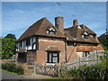
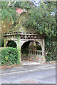
Old House Cottage, Ashford
On Church Road.
Image: © David Anstiss
Taken: 23 Aug 2009
0.24 miles
10
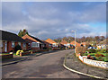
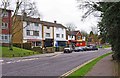
Midday Christmas 2009
Thirlmere, Kennington, Ashford.
A tidy cul-de-sac of mostly semi-detached bungalows, with no-one about - the residents either busy indoors preparing Christmas Dinner, or maybe away visiting friends and relations.
Image: © Richard Dorrell
Taken: 25 Dec 2009
0.24 miles