IMAGES TAKEN NEAR TO
Tilers Walk, ASHFORD, TN24 9BF
Introduction
This page details the photographs taken nearby to Tilers Walk, TN24 9BF by members of the Geograph project.
The Geograph project started in 2005 with the aim of publishing, organising and preserving representative images for every square kilometre of Great Britain, Ireland and the Isle of Man.

There are currently over 7.5m images from over14,400 individuals and you can help contribute to the project by visiting https://www.geograph.org.uk
Image Map
Images are licensed for reuse under creativecommons.org/licenses/by-sa/2.0
Notes
- Clicking on the map will re-center to the selected point.
- The higher the marker number, the further away the image location is from the centre of the postcode.
Image Listing (7 Images Found)
Images are licensed for reuse under creativecommons.org/licenses/by-sa/2.0
Image
Details
Distance
2
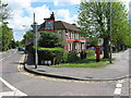
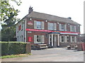
The Rose Inn, Kennington
On junction of Ulley Road (on left) and A2042 Faversham Road (on right).
Image: © David Anstiss
Taken: 28 Apr 2009
0.20 miles
3

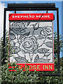
The Rose Inn, Pub Sign, Kenardington
Outside the pub on the Faversham Road.
Almost obscured by a large buddleia bush.
Image: © David Anstiss
Taken: 12 Sep 2010
0.20 miles
5
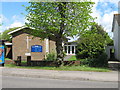
Kennington United Reformed / Methodist Church
On A2042 Faversham Road.
Image: © David Anstiss
Taken: 28 Apr 2009
0.21 miles
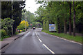
6

Ashford : Faversham Road
Looking towards Eastwell Towers from the junction of Faversham Road and Trinity Road
Image: © Chris Morley
Taken: 16 Feb 2008
0.24 miles
7
A2042 junction with A251, near Ashford
This is Faversham Road and curves north east, whilst at the left turn, Trinity road takes one in to Ashford.
Image: © J.Hannan-Briggs
Taken: 26 May 2014
0.25 miles