IMAGES TAKEN NEAR TO
Chiltern End, ASHFORD, TN24 8QJ
Introduction
This page details the photographs taken nearby to Chiltern End, TN24 8QJ by members of the Geograph project.
The Geograph project started in 2005 with the aim of publishing, organising and preserving representative images for every square kilometre of Great Britain, Ireland and the Isle of Man.

There are currently over 7.5m images from over14,400 individuals and you can help contribute to the project by visiting https://www.geograph.org.uk
Image Map
Images are licensed for reuse under creativecommons.org/licenses/by-sa/2.0
Notes
- Clicking on the map will re-center to the selected point.
- The higher the marker number, the further away the image location is from the centre of the postcode.
Image Listing (56 Images Found)
Images are licensed for reuse under creativecommons.org/licenses/by-sa/2.0
Image
Details
Distance
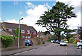
1
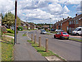
Quantock Drive, Ashford
Looking north east, with the entrance to Mendip on the left.
Image: © Richard Dorrell
Taken: 30 Jul 2009
0.04 miles
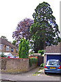
2
Belmore Park, Ashford
Another tall tree among the modern houses in this cul-de-sac.
See also http://www.geograph.org.uk/photo/1441910 , http://www.geograph.org.uk/photo/1441914 and http://www.geograph.org.uk/photo/1441902 .
Image: © Richard Dorrell
Taken: 30 Jul 2009
0.06 miles
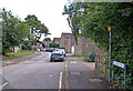
3
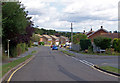
Quantock Drive, Ashford
Looking north east, with the entrance to Chiltern End on the right.
Image: © Richard Dorrell
Taken: 30 Jul 2009
0.07 miles
4
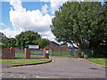
St Teresa's RC Primary School, Ashford
Entrance from Quantock Drive. The school has about 215 pupils, aged from 5 to 11.
School website - https://www.st-teresas.kent.sch.uk/ .
Image: © Richard Dorrell
Taken: 30 Jul 2009
0.09 miles
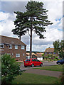
5
Belmore Park, Ashford
The beautiful cedar tree was there long before the modern housing estate was built.
Image: © Richard Dorrell
Taken: 30 Jul 2009
0.09 miles
6
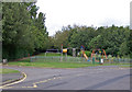
Children's playground, Quantock Drive
The playground is deserted on this sunny day in the school summer holidays - children prefer to watch TV or play computer games these days...
The road entrance on the left is into Highworth Grammar School. Beyond is the footpath to Warren Lane.
Image: © Richard Dorrell
Taken: 30 Jul 2009
0.11 miles
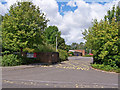
7
Belmore Park, Ashford
This is the vehicle access to the cul-de-sac from Quantock Drive.
There is pedestrian access to Magazine Road from the other end of the road.
Image: © Richard Dorrell
Taken: 30 Jul 2009
0.11 miles
8
Trees in Belmore Park, Ashford
The modern houses are built among a number of substantial trees.
See also http://www.geograph.org.uk/photo/1441902 , http://www.geograph.org.uk/photo/1441922 and http://www.geograph.org.uk/photo/1441910 .
Image: © Richard Dorrell
Taken: 30 Jul 2009
0.12 miles
9
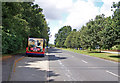
A28, Simone Weil Avenue - westbound
The road is a dual carriageway.
Image: © Richard Dorrell
Taken: 30 Jul 2009
0.13 miles
10
Highworth Grammar School. Ashford
This is the entrance from Quantock Drive.
The school is a Music specialist school, and has been on its present site since 1928.
School website - http://www.highworthgrammar.co.uk/ .
Image: © Richard Dorrell
Taken: 30 Jul 2009
0.14 miles