IMAGES TAKEN NEAR TO
Javelin Way, TN24 8FN
Introduction
This page details the photographs taken nearby to Javelin Way, TN24 8FN by members of the Geograph project.
The Geograph project started in 2005 with the aim of publishing, organising and preserving representative images for every square kilometre of Great Britain, Ireland and the Isle of Man.

There are currently over 7.5m images from over14,400 individuals and you can help contribute to the project by visiting https://www.geograph.org.uk
Image Map
Images are licensed for reuse under creativecommons.org/licenses/by-sa/2.0
Notes
- Clicking on the map will re-center to the selected point.
- The higher the marker number, the further away the image location is from the centre of the postcode.
Image Listing (31 Images Found)
Images are licensed for reuse under creativecommons.org/licenses/by-sa/2.0
Image
Details
Distance
1
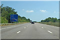
Coast-bound M20
At one mile to junction 10.
Image: © Robin Webster
Taken: 8 Jul 2018
0.05 miles


8
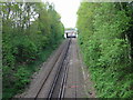
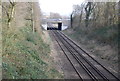
Looking N along railway line from Ashford
This is the Ashford - Wye - Canterbury line, the bridge carries the M20 London to Folkestone motorway.
Image: © Nick Smith
Taken: 3 May 2008
0.16 miles
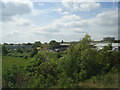
10
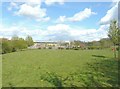
New housing in Gordon Close, Ashford
A framework for a roof can be seen on the left.
Image: © John Baker
Taken: 22 Apr 2012
0.17 miles