IMAGES TAKEN NEAR TO
Wellesley Villas, Wellesley Road, ASHFORD, TN24 8EL
Introduction
This page details the photographs taken nearby to Wellesley Villas, Wellesley Road, TN24 8EL by members of the Geograph project.
The Geograph project started in 2005 with the aim of publishing, organising and preserving representative images for every square kilometre of Great Britain, Ireland and the Isle of Man.

There are currently over 7.5m images from over14,400 individuals and you can help contribute to the project by visiting https://www.geograph.org.uk
Image Map
Images are licensed for reuse under creativecommons.org/licenses/by-sa/2.0
Notes
- Clicking on the map will re-center to the selected point.
- The higher the marker number, the further away the image location is from the centre of the postcode.
Image Listing (219 Images Found)
Images are licensed for reuse under creativecommons.org/licenses/by-sa/2.0
Image
Details
Distance
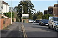
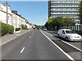
5
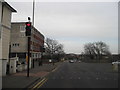
Mace Lane at the junction of Wellesley Road
Image: © David Howard
Taken: 21 Apr 2013
0.04 miles
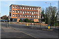
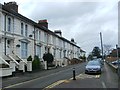
7
Charter House, Ashford
An impressive block on the corner of Wellesley Road and Mace Lane
Image: © David Howard
Taken: 21 Apr 2013
0.06 miles
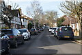
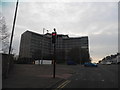
9
Ashford, Somerset Road
Ashford, Somerset Road, A292.
Image: © Helmut Zozmann
Taken: 31 Jul 2011
0.08 miles
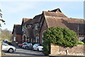
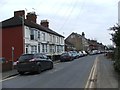
10
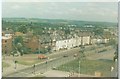
Somerset Road, Ashford in 1985
Taken from the top of the multi-storey carpark showing Somerset Road (part of Ashford's ring way) and its junction with Canterbury Road.
Image: © John Baker
Taken: 25 May 1985
0.08 miles