IMAGES TAKEN NEAR TO
Cradlebridge Drive, ASHFORD, TN24 0RF
Introduction
This page details the photographs taken nearby to Cradlebridge Drive, TN24 0RF by members of the Geograph project.
The Geograph project started in 2005 with the aim of publishing, organising and preserving representative images for every square kilometre of Great Britain, Ireland and the Isle of Man.

There are currently over 7.5m images from over14,400 individuals and you can help contribute to the project by visiting https://www.geograph.org.uk
Image Map
Images are licensed for reuse under creativecommons.org/licenses/by-sa/2.0
Notes
- Clicking on the map will re-center to the selected point.
- The higher the marker number, the further away the image location is from the centre of the postcode.
Image Listing (42 Images Found)
Images are licensed for reuse under creativecommons.org/licenses/by-sa/2.0
Image
Details
Distance
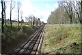
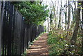
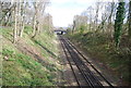
4
Stour Valley Walk crosses the railway line
Image: © N Chadwick
Taken: 4 Apr 2012
0.04 miles
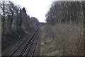
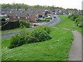
5
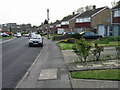
Looking S along Cradle Bridge Drive
The Stour Valley Walk path turns right between the houses, marked by the signpost by the car.
Image: © Nick Smith
Taken: 3 May 2008
0.04 miles
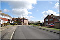
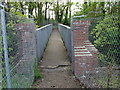
10
Cradle Bridge Drive from the motorway footbridge
For the Stour Valley Walk; follow Cradle Bridge Drive to the right, past the entrance to Birch Close and then turn right through a gap in the houses here http://www.geograph.org.uk/photo/800015
Image: © Nick Smith
Taken: 3 May 2008
0.08 miles