IMAGES TAKEN NEAR TO
Riverbank Way, ASHFORD, TN24 0PZ
Introduction
This page details the photographs taken nearby to Riverbank Way, TN24 0PZ by members of the Geograph project.
The Geograph project started in 2005 with the aim of publishing, organising and preserving representative images for every square kilometre of Great Britain, Ireland and the Isle of Man.

There are currently over 7.5m images from over14,400 individuals and you can help contribute to the project by visiting https://www.geograph.org.uk
Image Map
Images are licensed for reuse under creativecommons.org/licenses/by-sa/2.0
Notes
- Clicking on the map will re-center to the selected point.
- The higher the marker number, the further away the image location is from the centre of the postcode.
Image Listing (18 Images Found)
Images are licensed for reuse under creativecommons.org/licenses/by-sa/2.0
Image
Details
Distance
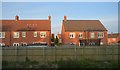
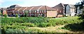
1
New houses, South Willesborough, Ashford
Image: © Julian P Guffogg
Taken: 30 May 2009
0.03 miles

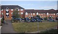
7
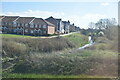
Town houses on East Stour Way
As seen from the bridleway heading towards Fairfield Drive. Recent additions to Ashfords housing stock.
Image: © David Anstiss
Taken: 30 May 2010
0.09 miles
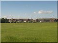
8

Fairview Drive
New housing estate at South Willesborough. Clover Court is to the right.
Image: © Oast House Archive
Taken: 31 May 2011
0.11 miles