IMAGES TAKEN NEAR TO
The Street, ASHFORD, TN24 0NB
Introduction
This page details the photographs taken nearby to The Street, TN24 0NB by members of the Geograph project.
The Geograph project started in 2005 with the aim of publishing, organising and preserving representative images for every square kilometre of Great Britain, Ireland and the Isle of Man.

There are currently over 7.5m images from over14,400 individuals and you can help contribute to the project by visiting https://www.geograph.org.uk
Image Map
Images are licensed for reuse under creativecommons.org/licenses/by-sa/2.0
Notes
- Clicking on the map will re-center to the selected point.
- The higher the marker number, the further away the image location is from the centre of the postcode.
Image Listing (59 Images Found)
Images are licensed for reuse under creativecommons.org/licenses/by-sa/2.0
Image
Details
Distance
3
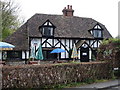
Cottage Hotel
Warren Cottage Hotel from The Street
Image: © D-G-Seamon
Taken: 24 Apr 2007
0.04 miles
4
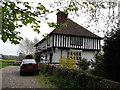
The Old Black and White House
Looking east from The Street to The Old Black and White House
Image: © D-G-Seamon
Taken: 24 Apr 2007
0.05 miles
5
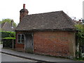
Possible Toll House?
This unusual building in The Street could be a Toll House
Image: © D-G-Seamon
Taken: 24 Apr 2007
0.05 miles
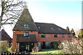
6
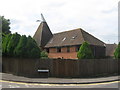
Lacton Oast
On Lacton Oast Road in Ashford.
Image: © David Anstiss
Taken: 4 Jun 2009
0.07 miles
7
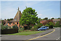
Lacton Oast, Lacton Oast, Willesborough, Kent
Image: © Oast House Archive
Taken: 3 May 2008
0.08 miles
9
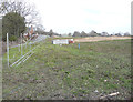
Hinxhill Park, Hythe Road (A20)
Planning permission has been granted by Ashford Borough Council under application number 16/01722/AS for “full planning application for a new link road to the rear of the William Harvey Hospital from the A20 and 192 dwellings together with associated open space, play equipment, landscaping, drainage, infrastructure and earthworks”.
Here the land is being levelled.
This view of Image is slightly to the northeast.
Image: © John Baker
Taken: 21 Feb 2019
0.09 miles
10
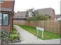
Snowdrop Place, Hinxhill Park
Planning permission has been granted by Ashford Borough Council under application number 16/01722/AS for “full planning application for a new link road to the rear of the William Harvey Hospital from the A20 and 192 dwellings together with associated open space, play equipment, landscaping, drainage, infrastructure and earthworks”.
Image: © John Baker
Taken: 24 Oct 2021
0.09 miles