IMAGES TAKEN NEAR TO
Boys Hall Road, ASHFORD, TN24 0LA
Introduction
This page details the photographs taken nearby to Boys Hall Road, TN24 0LA by members of the Geograph project.
The Geograph project started in 2005 with the aim of publishing, organising and preserving representative images for every square kilometre of Great Britain, Ireland and the Isle of Man.

There are currently over 7.5m images from over14,400 individuals and you can help contribute to the project by visiting https://www.geograph.org.uk
Image Map
Images are licensed for reuse under creativecommons.org/licenses/by-sa/2.0
Notes
- Clicking on the map will re-center to the selected point.
- The higher the marker number, the further away the image location is from the centre of the postcode.
Image Listing (21 Images Found)
Images are licensed for reuse under creativecommons.org/licenses/by-sa/2.0
Image
Details
Distance
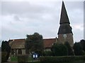
2
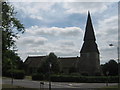
St Mary the Virgin Church, South Willesborough
Parish church on the junction of Bentley Road (on right) and Sevington Lane (on left).
Image: © David Anstiss
Taken: 4 Jun 2009
0.17 miles
3
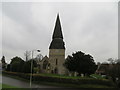
The Church of St Mary at Willesborough
Viewed from the west.
Image: © Peter Wood
Taken: 13 Feb 2016
0.18 miles
4
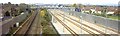
Luggage To The Fore
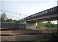
A passenger train from Dover Western Docks, bound for Charing Cross, approaches Ashford. Leading the train is a class 419 Motor Luggage Van. 10 of these single car units were built specifically for the 'Boat Trains', entering service in 1959. They were equipped with batteries permitting them to operate in the non-electrified quayside areas of the docks. All were withdrawn from normal service in 1991/2 with the impending closure of Dover Western Docks station (finally closed in 1994). They went on to see service as departmental units and also as depot shunters before all were finally withdrawn, the last going in 2004. 8 of the original 10 have been preserved.
On the right of the photo is Crowbridge Road, seen climbing to join Boys Hall Road which crosses the railway on the bridge. The bridge has been replaced by a modern concrete structure as part of the construction of the Channel Tunnel high speed rail link and Crowbridge Road now passes underneath before connecting via a slip road on the opposite side. A similar view today would show the rail link on the left of this photo.
Image: © Martin Addison
Taken: Unknown
0.19 miles
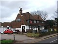
7
The William Harvey Public house, Willesborough
On junction of Sevington Lane (on right) and Church Road (in front).
Image: © David Anstiss
Taken: 4 Jun 2009
0.20 miles
8
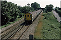
Channel Tunnel Rail Link, Willesborough, Ashford
The line from Folkestone can be seen to the left of the four track 186 mph rail link. Ahead this leaps over the line from Canterbury on a mile-long viaduct. The tower blocks of Ashford town centre can be seen on the horizon.
Image: © Adam Colton
Taken: 30 Oct 2005
0.20 miles
9

View from Sevington Loop
View across the domestic lines to the High Speed Lines from Sevington Loop.
Image: © Roger Templeman
Taken: 21 Aug 2010
0.21 miles
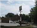
10
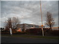
Carpet warehouse on Crowbridge Road, Sevington
Image: © David Howard
Taken: 10 Apr 2016
0.21 miles