IMAGES TAKEN NEAR TO
Breadlands Road, ASHFORD, TN24 0EP
Introduction
This page details the photographs taken nearby to Breadlands Road, TN24 0EP by members of the Geograph project.
The Geograph project started in 2005 with the aim of publishing, organising and preserving representative images for every square kilometre of Great Britain, Ireland and the Isle of Man.

There are currently over 7.5m images from over14,400 individuals and you can help contribute to the project by visiting https://www.geograph.org.uk
Image Map
Images are licensed for reuse under creativecommons.org/licenses/by-sa/2.0
Notes
- Clicking on the map will re-center to the selected point.
- The higher the marker number, the further away the image location is from the centre of the postcode.
Image Listing (12 Images Found)
Images are licensed for reuse under creativecommons.org/licenses/by-sa/2.0
Image
Details
Distance
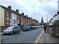
2
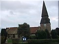
The Church of St Mary at Willesborough
Viewed from the west.
Image: © Peter Wood
Taken: 13 Feb 2016
0.08 miles
3
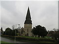
St Mary the Virgin Church, South Willesborough
Parish church on the junction of Bentley Road (on right) and Sevington Lane (on left).
Image: © David Anstiss
Taken: 4 Jun 2009
0.09 miles
4
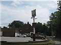
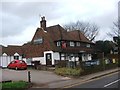
The William Harvey Public house, Willesborough
On junction of Sevington Lane (on right) and Church Road (in front).
Image: © David Anstiss
Taken: 4 Jun 2009
0.10 miles
8
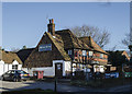
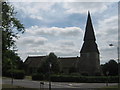
William Harvey Pub
Opposite the church.
Image: © Julian P Guffogg
Taken: 11 Jan 2014
0.11 miles
10
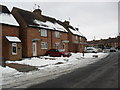
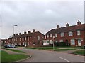
Bentley Road
1950s council houses in Willesborough.
Image: © Burgess Von Thunen
Taken: 8 Feb 2012
0.19 miles