IMAGES TAKEN NEAR TO
Cudworth Road, ASHFORD, TN24 0BD
Introduction
This page details the photographs taken nearby to Cudworth Road, TN24 0BD by members of the Geograph project.
The Geograph project started in 2005 with the aim of publishing, organising and preserving representative images for every square kilometre of Great Britain, Ireland and the Isle of Man.

There are currently over 7.5m images from over14,400 individuals and you can help contribute to the project by visiting https://www.geograph.org.uk
Image Map
Images are licensed for reuse under creativecommons.org/licenses/by-sa/2.0
Notes
- Clicking on the map will re-center to the selected point.
- The higher the marker number, the further away the image location is from the centre of the postcode.
Image Listing (16 Images Found)
Images are licensed for reuse under creativecommons.org/licenses/by-sa/2.0
Image
Details
Distance
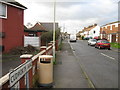
1
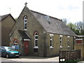
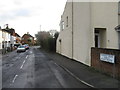
The Methodist Church, Ashford
On Cudworth Road in South Willesborough.
Image: © David Anstiss
Taken: 3 May 2009
0.05 miles
2
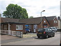
Salvation Army Place of Worship
On Cudworth Road. Church Hall beside is currently being used as a Polling Station for Council and European Elections for South Willesborough.
Image: © David Anstiss
Taken: 4 Jun 2009
0.07 miles
4
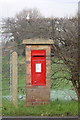
Post Box EIIR Brick Pillar
Where Herbert Road joins Earlesworth Road, adjacent to the footpath to the Recreation Ground, South Willesborough.
Image: © Mike Sharpe
Taken: 16 Dec 2009
0.12 miles
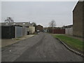
7
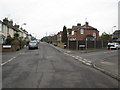
Crossroads of Earlsworth Road and Herbert Road
Image: © Matthew Chadwick
Taken: 28 Feb 2012
0.12 miles
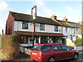
8
The Churchill Public House, South Willesborough
On Canterbury Road. Has large canopy for drinkers to sit out in the sun, also for smokers as well.
Image: © David Anstiss
Taken: 4 Jun 2009
0.13 miles
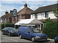
10
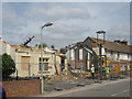
Demolishing the Crown and Anchor Pub
This was a public house on Canterbury Road. Further along the road is another pub (The Chartwell). This has survived but this has closed and now being demolished for another use.
Image: © David Anstiss
Taken: 4 Jun 2009
0.13 miles