IMAGES TAKEN NEAR TO
Harvey Road, ASHFORD, TN24 0AG
Introduction
This page details the photographs taken nearby to Harvey Road, TN24 0AG by members of the Geograph project.
The Geograph project started in 2005 with the aim of publishing, organising and preserving representative images for every square kilometre of Great Britain, Ireland and the Isle of Man.

There are currently over 7.5m images from over14,400 individuals and you can help contribute to the project by visiting https://www.geograph.org.uk
Image Map
Images are licensed for reuse under creativecommons.org/licenses/by-sa/2.0
Notes
- Clicking on the map will re-center to the selected point.
- The higher the marker number, the further away the image location is from the centre of the postcode.
Image Listing (33 Images Found)
Images are licensed for reuse under creativecommons.org/licenses/by-sa/2.0
Image
Details
Distance
5
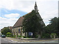
Christ Church, Willesborough
On junction of A292 Hythe Road (in front) and Albemarle Road (on left).
Image: © David Anstiss
Taken: 4 Jun 2009
0.14 miles
6
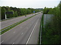
M20 looking in the direction of Folkestone and the coast
Image: © Nick Smith
Taken: 3 May 2008
0.15 miles
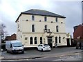
7
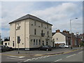
The Windmill Inn, Willesborough
Public house on A292 Hythe Road (in front) and Hunter Road (on left). Was once 'The Fox'.
Image: © David Anstiss
Taken: 4 Jun 2009
0.15 miles
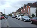
10
Willesborough Baptist Church
On A292 Hythe Road.
Image: © David Anstiss
Taken: 4 Jun 2009
0.17 miles